Stamping Ground in Scott County, Kentucky — The American South (East South Central)
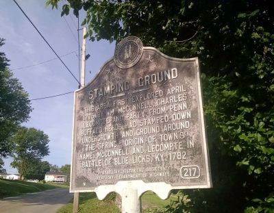
Stamping Ground
Erected by Kentucky Historical Society, Kentucky Department of Highways. (Marker Number 217.)
Topics and series. This historical marker is listed in these topic lists: Colonial Era • Settlements & Settlers. In addition, it is included in the Kentucky Historical Society series list. A significant historical date for this entry is April 29, 1775.
Location. 38° 16.261′ N, 84° 41.232′ W. Marker is in Stamping Ground, Kentucky, in Scott County. Marker is at the intersection of Woodlake Road (State Highway 1688) and Railroad Street, on the right when traveling south on Woodlake Road. Touch for map. Marker is in this post office area: Stamping Ground KY 40379, United States of America. Touch for directions.
Other nearby markers. At least 8 other markers are within 6 miles of this marker, measured as the crow flies. Buffalo Springs (within shouting distance of this marker); Stonetown (approx. half a mile away); Lindsay's Station (approx. 1˝ miles away); Branham's Mill / Galloway Pike Iron Bridge (approx. 3.2 miles away); Switzer Covered Bridge (approx. 4.2 miles away); St. Francis Church (approx. 4.4 miles away); U.S. Vice President (approx. 5.9 miles away); Johnson Family Cemetery (approx. 5.9 miles away). Touch for a list and map of all markers in Stamping Ground.
Credits. This page was last revised on June 16, 2016. It was originally submitted on June 5, 2015, by Dave Knoch of Scott County, Kentucky. This page has been viewed 523 times since then and 25 times this year. Photo 1. submitted on June 5, 2015, by Dave Knoch of Scott County, Kentucky. • Bill Pfingsten was the editor who published this page.
