Rogersville in Lauderdale County, Alabama — The American South (East South Central)
Lauderdale County High School 1912
Photographed by David J Gaines, October 5, 2013
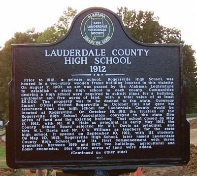
1. Lauderdale County High School 1912 Marker (side 1)
Prior to 1912, a private school, Rogersville High School, was housed in a two-story wooden frame building located in this vicinity. On August 7, 1907, an act was passed by the Alabama Legislature to establish a state high school in each county. Communities desiring a high school were required to submit plans for a building, equipment and five acres of land, with a total value of at least $5,000. The property was to be deeded to the state. Governor Emmet O’Neal visited Rogersville in October 1911 and gave his assurance that the high school for Lauderdale County would be located at Rogersville. On October 16, 1911, the trustees of the Rogersville High School Association conveyed to the state five acres of land and the existing building. That school closed on May 17, 1912, with Mr. W. R. Hale as principal. In early May 1912, the County School Board selected Mr. W. L. Davis as principal, and Mrs. W. L. Davis and Mr. C. W. Williams as teachers for the state high school. It opened on September 10, 1912, with 112 students. On May 20, 1913 Rogersville High School, later named Lauderdale County High School, held its first
this page online
Photographed by David J Gaines, October 5, 2013
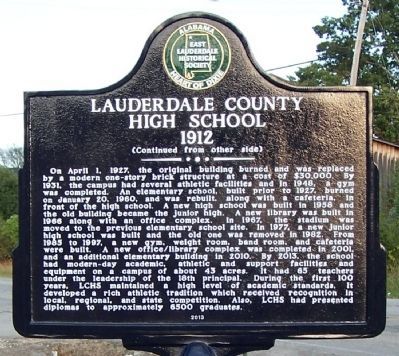
2. Lauderdale County High School 1912 Marker (side 2)
Erected 2013 by East Lauderdale Historical Society.
Topics. This historical marker is listed in this topic list: Education. A significant historical month for this entry is January 1807.
Location. 34° 49.61′ N, 87° 17.447′ W. Marker is in Rogersville, Alabama, in Lauderdale County. It is at the intersection of College Street and Williams Street, on the left when traveling east on College Street. Touch for map. Marker is in this post office area: Rogersville AL 35652, United States of America. Touch for directions.

Regionally, this marker is in North Alabama and in the Shoals. It is also in the American South, specifically in the Deep South, in Appalachia, and specifically in Southern Appalachia. Globally, it is in North America, a Gulf of Mexico state, the Western Hemisphere, the Western World, and the Anglosphere. Historically, it finds itself in what was once the territory of the Mississippian Culture, one of the Confederate States of America, and the Antebellum South.
Other nearby markers. At least 8 other markers are within 2 miles of this marker, measured as the crow flies: First Baptist Church of Rogersville (about 300 feet away, measured in a direct line); Lamb’s Ferry Road (approx. ¼ mile away); Heritage Park (approx. ¼ mile away); Rogersville Presbyterian Church in the U.S.A. (approx. 0.3 miles away); Liberty Church / Liberty Cemetery (approx. 0.4 miles away); East End High School (approx. 1.2 miles away); Return of a Native (approx. 1½ miles away); Camp Drake Boy Scout Camp / Joe Wheeler State Park Negro Area (approx. 1½ miles away). Touch for a list and map of all markers in Rogersville.
Credits. This page was last revised on June 16, 2016. It was originally submitted on October 6, 2013, by David J Gaines of Pinson, Alabama. This page has been viewed 1,666 times since then and 140 times this year. Last updated on June 12, 2015, by J. Makali Bruton of Washington, District of Columbia. Photos: 1, 2. submitted on October 6, 2013, by David J Gaines of Pinson, Alabama. • Bill Pfingsten was the editor who published this page.
