Near Sparta in White County, Tennessee — The American South (East South Central)
WW II Tennessee Maneuvers
Phase I March - June, 1943
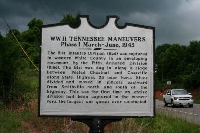
Photographed by Tom Bosse, May 31, 2015
1. WW II Tennessee Maneuvers Marker
Topics. This historical marker is listed in this topic list: War, World II.
Location. 35° 57.854′ N, 85° 38.282′ W. Marker is near Sparta, Tennessee, in White County. It is on U.S. 70 just west of Indian Mound Road, on the left when traveling east. Touch for map. Marker is in this post office area: Sparta TN 38583, United States of America. Touch for directions.

Regionally, this marker is in Tennessee’s Cumberland Plateau and in the Highland Rim. It is also in the American South, specifically in the Upper South, in Appalachia, and specifically in Southern Appalachia. Globally, it is in North America, the Western Hemisphere,
this page online
Other nearby markers. At least 8 other markers are within 10 miles of this marker, measured as the crow flies: Eli Sims (Simms) (approx. 3.8 miles away); Evins' Old Mill (approx. 8.4 miles away); Bragg Invades Kentucky (approx. 9.3 miles away); Dekalb County (approx. 9.8 miles away); Darrin Vincent (approx. 9.8 miles away); DeKalb County in the Civil War (approx. 9.8 miles away); Veterans Memorial DeKalb County Tennessee (approx. 9.8 miles away); DeKalb County Confederate Monument (approx. 9.8 miles away). Touch for a list and map of all markers in Sparta.

Photographed by Tom Bosse, May 31, 2015
2. WW II Tennessee Maneuvers Marker
Credits. This page was last revised on June 16, 2016. It was originally submitted on June 12, 2015, by Tom Bosse of Jefferson City, Tennessee. This page has been viewed 787 times since then and 56 times this year. Photos: 1, 2. submitted on June 12, 2015, by Tom Bosse of Jefferson City, Tennessee. • Bill Pfingsten was the editor who published this page.
