Near Spotsylvania Courthouse in Spotsylvania County, Virginia — The American South (Mid-Atlantic)
Social and Economic Richness in the Livingston District
Inscription.
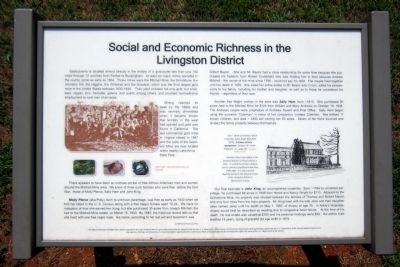
Spotsylvania is situated almost directly in the middle of a gold-pyrite belt that runs 140 miles through 12 counties from Fairfax to Buckingham. At least six major mines operated in the county, some as early as 1804. Those mines were the Mitchell Mine, the Grindstone, the Johnston Hill, the Higgins, the Whitehall and the Goodwin, which was the third largest gold mine in the United States between 1830-1849. Their yield included not only gold, but silver, lead, copper, zinc, hematite, galena, and quartz among others, and provided nontraditional employment to rural men of all races.
Mining reached its “peak by the 1880s and was severely diminished when it became known that territory in the west had opened and gold was found in California. The last commercial gold mine in Virginia closed in 1947 and the ruins of the Goodwin Mine are now located within nearby Lake Anna State Park.
There appears to have been an intimate pocket of free African American men and women around the Mitchell Mine area. We know of three such families who were free before the Civil War: those of Molly Pierce, Sally Ham and John King.
Molly Pierce (aka Polly), born to unknown parentage, was free as early as 1830 when we find her listed in the U.S. Census along with a free Negro female aged 10-24. We have no indication of how she earned her living, but she purchased 30 acres from Joseph Mitchell, the heir to the Mitchell Mine estate, on March 16, 1833. By 1840, the historical record tells us that she lived with one free negro male. His name, according to her last will and testament, was Gilbert Baylor. She and Mr. Baylor had a close relationship for some time because she purchased his freedom from Robert Crutchfield who was holding him in trust because Andrew Mitchell - the owner of the mine since 1796 - could not pay his debt. The couple lived together until her death in 1859. She willed her entire estate to Mr. Baylor who in turn, willed his possessions to his family, including his brother and daughter, as well as to those he considered his friends — regardless of their race.
Another free Negro woman in the area was Sally Ham, born -1810. She purchased 50 acres next to the Mitchell Mine for $125 from William and Mary Andrews on October 19, 1838. The Andrews couple were proprietors of Andrews Tavern and Post Office, Sally Ham began using the surname “Coleman” in honor of her companion, Lindsey Coleman. She birthed 11 known children, and died — 1890 still owning her 50 acres. Seven of her heirs survived and divided the family property between themselves.
Our final example is John King, an accomplished carpenter. Born ~1784 to unnamed parentage, he
purchased 68 acres in 1846 from Herod and Nancy Wright for $115. Adjacent to the Grindstone Mine, his property was situated between the families of Thomas and Robert Mastin and only four miles from the Ham property. Mr. King lived with his wife Jane and their daughter (also named Jane) until his death on May 7, 1860, of dropsy at age 76. In today's language, dropsy would best be described as swelling due to congestive heart failure. At the time of his death, his real estate was valued at $160 and his personal holdings were $35. His widow lived another 14 years, dying of graceful old age at 80 in 1874.
(captions)
(left side) Left to right: Gold, tool used to pour ore, hematite
(right side) Right: sketch of Andrews Tavern is courtesy James Roger Mansfield (1977), A History of Early Spotsylvania, Orange, VA: Green Publishers, Inc., page 147. (The book is owned by TL Miller)
Andrews Tavern was added to the National Register of Historic Places in 1976. Its architectural style is federal and its period of significance was from 1800-1849. It is now a private dwelling located in the Glenora section of the Livingston District in Spotsylvania County.
The African American Heritage Trail is supported in part by a Preserve America grant administered by the National Park Service, United States Department of the Interior. This
product is based upon work assisted by a grant from the U.S. Department of the Interior, National Park Service. Any opinions, findings, conclusions or recommendations expressed in this material are those of the author and do not necessarily reflect the views of the U.S. Department of the Interior.
Erected 2015 by Spotsylvania African American Heritage Trail.
Topics. This historical marker is listed in these topic lists: African Americans • Industry & Commerce. A significant historical month for this entry is March 1910.
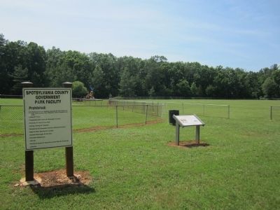
Location. 38° 11.642′ N, 77° 47.126′ W. Marker is near Spotsylvania Courthouse, Virginia, in Spotsylvania County. Marker can be reached from Post Oak Road (County Route 606) 0.6 miles west of Pamunkey Road (County Route 612), on the right when traveling west. Located in the parking lot of Chewning Park. Touch for map. Marker is at or near this postal address: 13013 Post Oak Rd, Spotsylvania VA 22551, United States of America. Touch for directions.
Other nearby markers. At least 8 other markers are within 8 miles of this marker, measured as the crow flies. Spotsylvania’s First African American Church (approx. 3.6 miles away); Spotsylvania's War Effort (approx. 6.4 miles away); A.P. Hill Escapes Capture (approx. 7.2 miles away); Key Terrain (approx. 7.2 miles away); Fredericksville Furnace (approx. 7.3 miles away); Wilderness Campaign (approx. 7.3 miles away); Todd’s Tavern (approx. 7.3 miles away); a different marker also named Todd’s Tavern (approx. 7.3 miles away). Touch for a list and map of all markers in Spotsylvania Courthouse.
Also see . . . Spotsylvania African American Heritage Trail. (Submitted on June 22, 2015.)
Credits. This page was last revised on November 14, 2021. It was originally submitted on June 22, 2015, by Bernard Fisher of Richmond, Virginia. This page has been viewed 365 times since then and 23 times this year. Photos: 1, 2, 3. submitted on June 22, 2015, by Bernard Fisher of Richmond, Virginia.


