Katy Trail State Park 25th Anniversary
1990 - 2015
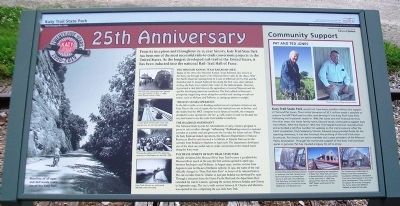
From its inception and throughout its 25-year history, Katy Trail State Park has been one of the most successful rails-to-trail conversions projects in the United States. As the longest developed rail-trail in the United States, it has been inducted into the national Rail-Trail Hall of Fame.
The Missouri-Kansas-Texas Railroad (MKT)
Begun in the 1870s, the Missouri-Kansas-Texas Railroad, also known as the Katy, ran through much of the Missouri River valley by the 1890s. With the Pacific Railroad running from St. Louis to Jefferson City by 1856 and the Hannibal and St. Joseph Railroad becoming the first cross-state railroad in 1859, the Katy was a relative late comer to the railroad game. However, it provided a vital link between the agriculture of central Missouri and the quickly developing American southwest. The Katy added to Missouri's prosperity, supporting towns along the corridor and causing several new towns, such as Mokane and Tebbetts, to spring up almost overnight.
The Katy Ceases Operation
In the fall of 1986, the Katy experienced severe flooding that washed out several miles of track. Due to the cost of repair, the fact that railroad use was in decline, and the company was in financial trouble, the company decided to cease operations. On Oct. 4, 1986, trains 101 and 102 became the very last trains to use the corridor and the Katy ceased operations on its route from Sedalia to Machens.
The Railroad Amendment
The National Trails System Act Amendments of 1983 provide that railroad corridors no longer needed for active rail service can be banked for future transportation needs and used on an interim basis for recreational trails. When the Katy Railroad ceased operations, the Missouri Department of Natural Resources filed for a certificate of interim trail use for the corridor from Sedalia to Machens and it was granted in April 1987. The department used the opportunity to develop one of the most successful rails-to-trails conversions in the United States.
The Development of Katy Trail State Park
Initially christened the Missouri River State Trail because it paralleled the Missouri River much of the way, the first section opened in April 1990 between Rocheport and McBaine. In August 1990, another section from Augusta to just north of Defiance opened. In 1991, the name of the trail officially changed to "Katy Trail State Park" in honor of its railroad history. The rail corridor from St. Charles to just past Sedalia was developed by 1996. Through a donation from the Union Pacific Railroad, the department then extended the trail to Clinton, opening the section between Sedalia and Clinton in September 1999. The last 12-mile section
Community Support
Pat and Ted Jones
Katy Trail State Park would not have been possible without the support of Ted and Pat Jones. Their initial donation of $2.2 million made it possible to acquire the MKT Railroad corridor and develop it into Katy Trail State Park. Following her husband's death, Pat Jones and the financial-services firm that bears the Jones family name, Edward Jones, continued to support Katy Trail efforts. After the flood of 1993, the firm helped fund trail reconstruction and provided a toll-free number for updates on the trail's progress. After the trail's completion from Sedalia to Clinton, Edward Jones provided funds for the opening ceremony; it has also financed the printing of the trail's full-color brochures. Pat Jones is an active member and a past president of the Missouri Parks Association. Through her continued support of the Katy Trail and state parks in general, Pat has created a legacy for all to enjoy.
Erected by Edward Jones and Missouri Department of Natural Resources.
Topics and series. This historical marker is listed in these topic lists: Charity & Public Work • Railroads & Streetcars. In addition, it is included in the Katy Trail State Park series list. A significant historical month for this entry is April 1987.
Location.
Other nearby markers. At least 8 other markers are within walking distance of this marker. History of Sedalia (a few steps from this marker); Sedalia Points of Interest (a few steps from this marker); Sedalia to Clifton City (a few steps from this marker); Sedalia to Green Ridge (a few steps from this marker); Katy Depot (within shouting distance of this marker); Sedalia's Rag Tag Train (within shouting distance of this marker); Veterans Memorial (approx. 0.3 miles away); Vietnam War Memorial (approx. 0.4 miles away). Touch for a list and map of all markers in Sedalia.
Also see . . .
1. Katy Trail State Park. (Submitted on July 11, 2015, by William Fischer, Jr. of Scranton, Pennsylvania.)
2. Bike Katy Trail. (Submitted on July 11, 2015, by William Fischer, Jr. of Scranton, Pennsylvania.)
Credits. This page was last revised on June 16, 2016. It was originally submitted on July 11, 2015, by William Fischer, Jr. of Scranton, Pennsylvania. This page has been viewed 278 times since then and 6 times this year. Photos: 1, 2. submitted on July 11, 2015, by William Fischer, Jr. of Scranton, Pennsylvania.

