San Cristóbal, Jutiapa, Guatemala — Central America
Amatal River Bridge
Photographed by J. Makali Bruton, July 11, 2015
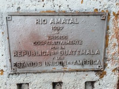
1. Amatal River Bridge Marker

1937
Erigido
Cooperativamente
por la
Republica de Guatemala
y los
Estados Unidos de America
1937
Erected cooperatively by the Republic of Guatemala and the United States of America
Erected 1937.
Topics. This historical marker is listed in this topic list: Bridges & Viaducts. A significant historical year for this entry is 1937.
Location. 14° 11.731′ N, 89° 40.488′ W. Marker is in San Cristóbal, Jutiapa. It is on Panamerican Highway, on the right when traveling east. Touch for map. Marker is in this post office area: San Cristóbal, Jutiapa 22019, Guatemala. Touch for directions.

Regionally, it is in North America, specifically in Central America, in Mesoamerica, on the Ring of Fire, on the Pacific Rim, and in the Western Hemisphere. Historically, it finds itself in what was once New Spain and also a Spanish colony.
Other nearby markers. At least 4 other markers are within 26 kilometers of this marker, measured as the crow flies: Tamasulapa River Bridge (approx. 12.9 kilometers away); Ecological Park "San Lorenzo" (approx. 24.8 kilometers away in
this page online
Photographed by J. Makali Bruton, July 11, 2015
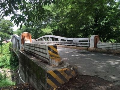
2. Wide view of Amatal River Bridge Marker
The marker can be seen on the pillar on the right side of the bridge.
Credits. This page was last revised on March 2, 2018. It was originally submitted on July 12, 2015, by J. Makali Bruton of Washington, District of Columbia. This page has been viewed 436 times since then and 8 times this year. Photos: 1, 2. submitted on July 12, 2015, by J. Makali Bruton of Washington, District of Columbia. • Andrew Ruppenstein was the editor who published this page.
