Near Granville in Charles City County, Virginia — The American South (Mid-Atlantic)
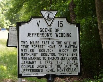
Scene of Jefferson’s Wedding
Erected 1960 by Virginia State Library. (Marker Number V-15.)
Topics and series. This historical marker is listed in this topic list: Colonial Era. In addition, it is included in the Former U.S. Presidents: #03 Thomas Jefferson, and the Virginia Department of Historic Resources (DHR) series lists. A significant historical date for this entry is January 1, 1781.
Location. Marker is missing. It was located near 37° 22.583′ N, 77° 13.488′ W. Marker was near Granville, Virginia, in Charles City County. Marker was at the intersection of John Tyler Memorial Highway (Virginia Route 5) and Wayside Road (County Route 607), on the right when traveling east on John Tyler Memorial Highway. Touch for map. Marker was in this post office area: Charles City VA 23030, United States of America. Touch for directions.
Other nearby markers. At least 8 other markers are within 3 miles of this location, measured as the crow flies. Wayside & Granville (here, next to this marker); Malvern Hill (approx. 1˝ miles away); Shirley (approx. 1.9 miles away); Aggy's Freedom Suit (approx. 1.9 miles away); The Fergusons of Malvern Hill (approx. 1.9 miles away); Benjamin Harrison (approx. 2.4 miles away); Seven Days Battles (approx. 2.8 miles away); Union Reserves (approx. 2.8 miles away).
Regarding Scene of Jefferson’s Wedding. Monticello is about 90 miles away. They must have spent at least three days on the road, spending the night at inns or friend’s homes along the way.
Credits. This page was last revised on June 16, 2016. It was originally submitted on July 27, 2014, by J. J. Prats of Powell, Ohio. This page has been viewed 663 times since then and 42 times this year. Last updated on July 26, 2015, by J. Makali Bruton of Accra, Ghana. Photo 1. submitted on July 26, 2015, by J. Makali Bruton of Accra, Ghana. • Bill Pfingsten was the editor who published this page.
Editor’s want-list for this marker. A wide shot of the marker and its surroundings. • Can you help?
