Near Gladstone in Amherst County, Virginia — The American South (Mid-Atlantic)
Nelson County
⎯⎯⎯
Amherst County
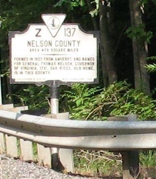
Photographed by Laura Troy, July 23, 2008
1. Nelson County Marker
Nelson County. Area 473 Square Miles. Formed in 1807 from Amherst, and named for General Thomas Nelson, Governor of Virginia, 1781. Oak Ridge, an old home, is in this county.
Amherst County. Area 470 Square Miles. Formed in 1781 from Albemarle, and named for Jeffrey, Lord Amherst, British commander in the French and Indian War. Balcony Falls are in this county.
Erected 1934 by Conservation and Development Commission. (Marker Number Z-137.)
Topics and series. This historical marker is listed in this topic list: Settlements & Settlers. In addition, it is included in the Virginia Department of Historic Resources (DHR) series list. A significant historical year for this entry is 1807.
Location. 37° 34.212′ N, 78° 54.692′ W. Marker is near Gladstone, Virginia, in Amherst County. It is on Richmond Highway (U.S. 60) west of Pidemont Road, on the left when traveling east. Touch for map. Marker is in this post office area: Gladstone VA 24553, United States of America. Touch for directions.

Regionally, this marker is in Central Virginia. It is also in the American South and specifically in the Upper South. Globally,
this page online
Other nearby markers. At least 8 other markers are within 8 miles of this marker, measured as the crow flies: Diuguidsville (approx. 5.2 miles away); The Scale House (approx. 6 miles away); Action at Tye River (approx. 6½ miles away); Veterans Memorial Trees (approx. 6.6 miles away); Central High School (approx. 6.6 miles away); The Amherst Depot (approx. 7.4 miles away); Grave of Patrick Henry’s Mother (approx. 7½ miles away); Boyhood Home of Rev. Dr. W.A.R. Goodwin (1869-1939) (approx. 7.6 miles away).
More about this marker. There is nowhere to park to view this marker.
Credits. This page was last revised on August 3, 2024. It was originally submitted on August 14, 2008, by Laura Troy of Burke, Virginia. This page has been viewed 1,021 times since then and 34 times this year. Last updated on July 26, 2015, by J. Makali Bruton of Washington, District of Columbia. Photo 1. submitted on August 14, 2008, by Laura Troy of Burke, Virginia. • Bill Pfingsten was the editor who published this page.
Editor’s want-list for this marker. A better photo of the marker's front and a photo of the marker's reverse. • A wide shot of the marker in context. • Can you help?
