Fort Laramie in Goshen County, Wyoming — The American West (Mountains)
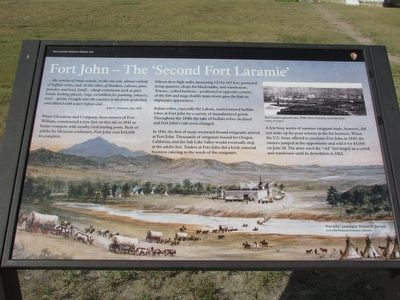
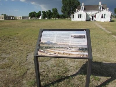
Fort John – The ‘Second Fort Laramie’
Fort Laramie National Historic Site
Photographed by Bill Coughlin, August 2, 2015
1. Fort John – The ‘Second Fort Laramie’ Marker
. . . the articles of trade consist, on the one side, almost entirely of buffalo robes; and, on the other, of blankets, calicoes, guns, powder, and lead, [and] . . . cheap ornaments such as glass beads, looking-glasses, rings, vermillion for painting, tobacco, and . . . spirits, brought into the country in the form of alcohol, and diluted with water before sold . . .
Pierre Chouteau and Company, then owners of Fort William, constructed a new fort on this site in 1841 to better compete with nearby rival trading posts. Built of adobe by Mexican craftsmen, Fort John cost $10,000 to complete.
Fifteen-foot-high walls, measuring 121 by 167 feet, protected living quarters, shops for blacksmiths, and warehouses. Towers – called bastions – positioned at opposite corners of the fort and large double main doors gave the fort an impressive appearance.
Indian tribes, especially the Lakota, traded tanned buffalo robes at Fort John for a variety of manufactured goods. Throughout the 1840s the take of buffalo robes declined and Fort John’s role soon changed.
In 1841, the first of many westward-bound emigrants
this page online
A few busy weeks of summer emigrant trade, however, did not make up for poor returns in the fur business. When the U.S. Army offered to purchase Fort John in 1849, the owners jumped at the opportunity and sold it for $4,000 on June 26. The army used the “old” fort largely as a corral and warehouse until its demolition in 1862.
Erected by National Park Service.
Topics. This historical marker is listed in these topic lists: Exploration • Forts and Castles • Industry & Commerce. A significant historical month for this entry is June 1912.
Location. 42° 12.065′ N, 104° 33.544′ W. Marker is in Fort Laramie, Wyoming, in Goshen County. It can be reached from State Highway 160, on the left when traveling west. Marker is located at Fort Laramie National Historic Site. Touch for map. Marker is in this post office area: Fort Laramie WY 82212, United States of America. Touch for directions.

Regionally,
Photographed by Bill Coughlin, August 2, 2015
2. Fort John – The ‘Second Fort Laramie’ Marker
Other nearby markers. At least 8 other markers are within walking distance of this marker: Fort William and the Fur Trade (here, next to this marker); The “Government Workhouse” (within shouting distance of this marker); Between Two Worlds … the American Métis (within shouting distance of this marker); Captain’s Quarters (within shouting distance of this marker); Reading, ‘Riting, and ‘Rithmetic (about 300 feet away, measured in a direct line); Refinement at Fort Laramie (about 300 feet away); Administration Building (about 400 feet away); Officers Quarters (about 400 feet away). Touch for a list and map of all markers in Fort Laramie.
More about this marker. A large painting of “Fort John” by William H. Jackson appears at the bottom of the marker. The upper
Photographed by Bill Coughlin, August 2, 2015
3. Marker at Fort Laramie
Also see . . . Fort Laramie National Historic Site. (Submitted on August 10, 2015, by Bill Coughlin of Woodland Park, New Jersey.)
Credits. This page was last revised on June 16, 2016. It was originally submitted on August 10, 2015, by Bill Coughlin of Woodland Park, New Jersey. This page has been viewed 1,578 times since then and 90 times this year. Photos: 1, 2, 3. submitted on August 10, 2015, by Bill Coughlin of Woodland Park, New Jersey.
