Mid-City in New Orleans in Orleans Parish, Louisiana — The American South (West South Central)
Charity Hospital Cemetery
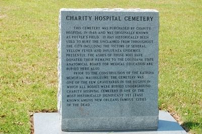
Front
This cemetery was purchased by Charity Hospital in 1848 and was originally known as Potter's Field. It has historically been used to bury the unclaimed victims from throughout the city including victims of several yellow fever and influenza epidemics. Presently the ashes of those who have donated their remains to the Louisiana State Anatomical Board for medical education are buried here also.
Prior to the construction of the Katrina Memorial mausoleums the cemetery was one of the few graveyards in the region in which all bodies were buried underground. Charity Hospital Cemetery is one of the most historically significant yet least known among New Orleans famous cities of the dead.
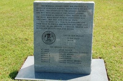
Reverse
This memorial honors those who perished as a result of Hurricane Katrina, which struck on August 29, 2005. This storm led to the greatest natural and man-made disaster in our nation's history.
This memorial provides a final resting place for those whose bodies remain unidentified and unclaimed. May they have eternal peace.
It also serves as a tribute to survivors and their work to rebuild New Orleans and their lives. Together we are creating a stronger, smarter and better New Orleans than ever before.
Erected by City Of New Orleans.
Topics. This historical marker is listed in these topic lists: Cemeteries & Burial Sites • Disasters. A significant historical year for this entry is 1848.
Location. 29° 58.851′ N, 90° 6.636′ W. Marker is in New Orleans, Louisiana, in Orleans Parish. It is in Mid-City. Marker is on Canal Street, 0.1 miles south of City Park Avenue, on the right when traveling south. Touch for map. Marker is in this post office area: New Orleans LA 70119, United States of America. Touch for directions.
Other nearby markers. At least 8 other markers are within walking distance of this marker. The New Orleans Katrina Memorial (a few steps from this marker); Site Of Higgins' Industries at Delgado Trade School (approx. 0.3 miles away); Holt Cemetery (approx. 0.4 miles away); a different marker also named Holt Cemetery (approx. 0.4 miles away); William Charles Cole Claiborne (approx. 0.4 miles away); Metairie Cemetery (approx. 0.4 miles away); a different marker also named Holt Cemetery (approx. 0.4 miles away); a different marker also named Holt Cemetery (approx. 0.4 miles away). Touch for a list and map of all markers in New Orleans.
Credits. This page was last revised on February 12, 2023. It was originally submitted on August 13, 2015. This page has been viewed 1,175 times since then and 156 times this year. Last updated on August 16, 2015. Photos: 1, 2, 3. submitted on August 13, 2015. • Bernard Fisher was the editor who published this page.


