Alexandria in Rapides Parish, Louisiana — The American South (West South Central)
Epps House
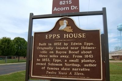
Photographed by Cajun Scrambler, May 18, 2005
1. Epps House Marker
Twelve Years A Slave.
Erected 1980 by Department of Culture, Recreation and Tourism.
Topics. This historical marker is listed in this topic list: African Americans. A significant historical year for this entry is 1852.
Location. 31° 10.509′ N, 92° 24.887′ W. Marker is in Alexandria, Louisiana, in Rapides Parish. It is on Water Tower Rd. (Acorn Dr.) 0.2 miles south of Middleton Dr., on the left when traveling south. Located on the campus of LSU-A (Louisiana State University - Alexandria Campus). Touch for map. Marker is at or near this postal address: 8215 Acorn Dr, Alexandria LA 71302, United States of America. Touch for directions.

Regionally, this marker is in Central Louisiana and in Acadiana — Cajun Country. It is also in the American South and specifically in the Deep South. Globally, it is in North America, a Gulf of Mexico state, the Western Hemisphere, the Western World, and the Anglosphere. Historically,
this page online
Other nearby markers. At least 8 other markers are within 6 miles of this marker, measured as the crow flies: Edwin Epps House (a few steps from this marker); a different marker also named Epps House (about 300 feet away, measured in a direct line); Oakland Hall (approx. 0.2 miles away); Headquarters 1st Calvary Division, Army of West La., May 8, 1864 (approx. ¼ mile away); Oakland Plantation (approx. 0.3 miles away); Potter's Grocery (approx. 5.9 miles away); Dr. Whitehead's Medical Office (approx. 5.9 miles away); Meeker Sugar Refinery Gears (approx. 6 miles away). Touch for a list and map of all markers in Alexandria.
More about this marker. House and marker were originally located in Bunkie, LA in Avoyelles Parish, some 20 miles south. Was moved to LSU-A campus in 1999 and restored.
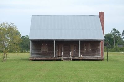
Photographed by Cajun Scrambler, May 18, 2005
2. Epps House
Credits. This page was last revised on June 4, 2023. It was originally submitted on August 7, 2015. This page has been viewed 1,127 times since then and 77 times this year. Last updated on August 16, 2015. Photos: 1, 2. submitted on August 7, 2015. • Bernard Fisher was the editor who published this page.
Editor’s want-list for this marker. A wide view photo of the marker and the surrounding area in context. • Can you help?
