
Wartrace in Bedford County, Tennessee — The American South (East South Central)
Wartrace
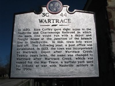
Photographed by Tom Gillard, December 26, 2009
1. Wartrace Marker
Erected by Tennessee Historical Commission. (Marker Number 3G 44.)
Topics and series. This historical marker is listed in this topic list: Settlements & Settlers. In addition, it is included in the Tennessee Historical Commission series list. A significant historical year for this entry is 1850.
Location. 35° 31.526′ N, 86° 20.04′ W. Marker is in Wartrace, Tennessee, in Bedford County. It is on Blackman Boulevard (Tennessee Route 64), on the right when traveling south. Touch for map. Marker is in this post office area: Wartrace TN 37183, United States of America. Touch for directions.

Regionally,
this page online
Other nearby markers. At least 8 other markers are within walking distance of this marker: Strolling Jim (about 700 feet away, measured in a direct line); Bandstand (approx. 0.2 miles away); Jimmy Cleveland (approx. 0.2 miles away); Andrew Jackson (approx. 0.2 miles away); "Dedicated to Those Brave & Gallant Soldiers in Butternut & Gray"! (approx. 0.2 miles away); Skirmish at Liberty Gap (approx. 0.2 miles away); Tullahoma Campaign (approx. 0.2 miles away); Skirmish at Wartrace (approx. ¼ mile away). Touch for a list and map of all markers in Wartrace.

Photographed by Tom Gillard, December 26, 2009
2. Wartrace welcome center and Marker
Credits. This page was last revised on June 16, 2016. It was originally submitted on December 26, 2009, by Tom Gillard of Tullahoma, Tennessee. This page has been viewed 2,332 times since then and 58 times this year. Last updated on September 9, 2015, by Steve Masler of Memphis, Tennessee. Photos: 1, 2. submitted on December 26, 2009, by Tom Gillard of Tullahoma, Tennessee. • Bill Pfingsten was the editor who published this page.
