Bayeux in Calvados, Normandy, France — Western Europe
Le Quartier du Pont Saint-Jean
Pont Saint-Jean District
— Bayeux, la Qualité a ses Racines —
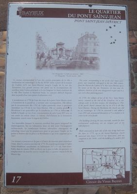
Ce secteur correspondant à l’une des entrées principales de la ville a entièrement été réaménage à la fin du XVIIIe siècle à partir de la maison du Cadran (n°6 rue Saint-Martin) jusqu’à l’angle de la rue des Teinturiers. Les grands travaux ont porté sur la recomposition du carrefour entre l’artère principale et la rue longeant les fossés extérieurs de la ville (rues Larcher et Maréchal Foch). Le caractère défensif disparaît alors au profit d’un vaste projet d’urbanisme civil.
L’écroulement en 1759 de l’une des tours de la porte Saint-Martin située à l’extrémité de la grand‘rue a entraîné cette recomposition. Elle débute par la reconstruction dès 1762 de l’église paroissiale située à proximité immédiate (au n°6 de la rue Saint-Martin). Elle est vendue pendant la Révolution à un quincaillier qui la transforme en 1794 en habitation. Il habille la façade sur rue d’une ornementation de style Louis XVI avec en son centre un cadran solaire. Le balcon, chef-d’œuvre de la ferronnerie bayeusaine, couvre toute la largeur de l’édifice.
Les immeubles formant le nouveau carrefour font partie intégrante du réaménagement. Sur ces habitations, dont on doit noter l’homogénéité architecturale, les nombreuses fenêtres rebouchées témoignent du subterfuge trouve par les propriétaires pour ne pas payer l’impôt sur les portes et fenêtres mis en place à la Révolution et qui n’est supprimé qu’en 1917.
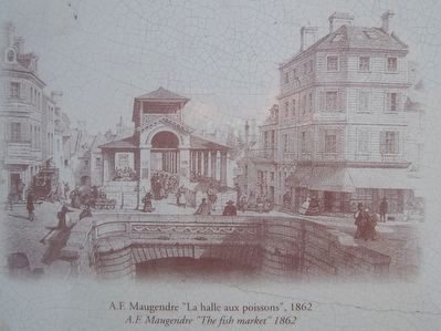
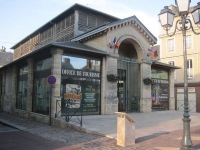
Les travaux se poursuivent de part et d’autre du nouveau pont enjambant l’Aure, dont la construction date de 1775. Ils se prolongent jusqu’à l’église Sainte-Madeleine transformée en habitations (n°5-13 rue Saint-Jean). Enfin, dans les années 1840 est élevée sur le pont la halle aux poissons, en remplacement du marché couvert installe dans ce quartier depuis la fin du Moyen Age.
This sector, corresponding to one of the city's main access points, was completely redesigned in the late 18th century, from the Maison du Cadran (n°6, Rue Saint-Martin) up to the corner of the Rue des Teinturiers. At that time the defensive character of the area disappeared to give way to a vast civil urban planning project.
In 1759, the collapse of one of the Porte Saint-martin towers, situated at the end of the Grand'rue led to this redesign with, in the first instance, the rebuilding in 1762, of the parish church situated close by (at n°6 in the rue Saint-martin). During the Revolution the church was sold to an ironmonger. In 1794 he converted it and added a Louis XVI style
ornamental decoration with a sundial in its centre to the street facade.
The buildings forming the new crossroads, notable for their architectural uniformity, are an integral part of the redevelopment.
Work continued on both sides of the new bridge built over the Aure in 1775, up to the sainte-Madeleine church converted into houses (n°5-13 rue Saint-Jean), and was completed in the 1840's, with the building of a modern fish market.
Erected by La ville de Bayeux. (Marker Number 17.)
Topics and series. This historical marker is listed in these topic lists: Industry & Commerce • Settlements & Settlers • Waterways & Vessels. In addition, it is included in the France - Bayeux - Circuit du Vieux Bayeux series list. A significant historical year for this entry is 1759.
Location. 49° 16.609′ N, 0° 42.058′ W. Marker is in Bayeux, Normandie (Normandy), in Calvados. Touch for map. Marker is in this post office area: Bayeux, Normandie 14400, France. Touch for directions.
Other nearby markers. At least 8 other markers are within walking distance of this marker. La Rue Saint-Jean (about 120 meters away, measured in a direct line); Autour des Augustines (about 150 meters away); Le palais Episcopal (about 180 meters away); L'Esplanade Flachat (about 210 meters away); Les Abords du Chevet de la Cathédrale
(about 210 meters away); Un édifice du Xe siècle (about 240 meters away); Le Rempart Gallo-Roman (about 240 meters away); L'Ancien Seminaire (approx. 0.3 kilometers away). Touch for a list and map of all markers in Bayeux.
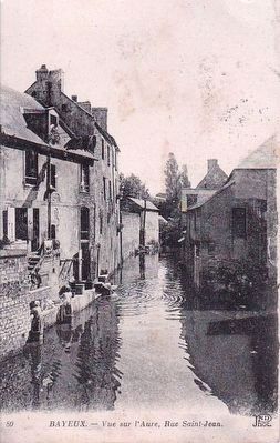
Postcard by ND Phot., circa 1910
4. Bayeaux - Vue sur l'Aure, Rue Saint-Jean
View on the Aure, taken from the bridge, across Rue Saint-Jean from the marker location. Note on the left of the picture there are 3 women washing laundry, and perhaps more peculiarly, standing atop barrels in the river to do so. (Click to enlarge image.)
Credits. This page was last revised on August 29, 2023. It was originally submitted on September 28, 2015, by Kevin W. of Stafford, Virginia. This page has been viewed 320 times since then and 16 times this year. Last updated on August 27, 2023, by Carl Gordon Moore Jr. of North East, Maryland. Photos: 1, 2, 3. submitted on September 28, 2015, by Kevin W. of Stafford, Virginia. 4. submitted on September 24, 2015. 5. submitted on September 28, 2015, by Kevin W. of Stafford, Virginia. • J. Makali Bruton was the editor who published this page.
