
Wheatland in Platte County, Wyoming — The American West (Mountains)
Wildlife Diversity
Wyoming’s Wildlife
Photographed By Bill Coughlin, August 2, 2015
1. Wildlife Diversity Marker
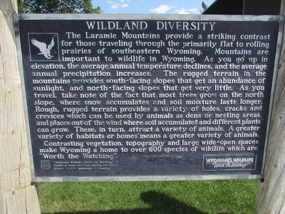
The Laramie Mountains provide a striking contrast for those traveling through the primarily flat to rolling prairies of southeastern Wyoming. Mountains are important to wildlife in Wyoming. As you go up in elevation, the average annual temperature declines, and the average annual precipitation increases. The rugged terrain in the mountains provides south-facing slopes that get an abundance of sunlight, and north-facing slopes that get very little. As you travel, take note of the fact that most trees grow on the north slope, where snow accumulates and soil moisture lasts longer. Rough, rugged terrain provides a variety of holes, cracks and crevices which can be used by animals as dens or nesting areas, and places out of the wind where soil accumulates and different plants can grow. These, in turn, attract a variety of animals. A greater variety of habitats or homes means a greater variety of animals.
Contrasting vegetation, topography and large wide-open spaces make Wyoming a home to over 600 species of wildlife which are “Worth the Watching”.
Erected by State of Wyoming.
Topics. This historical marker is listed in this topic list: Animals.
Location. 42° 14.055′ N, 105° 1.18′
this page online
Other nearby markers. At least 6 other markers are within 10 miles of this marker, measured as the crow flies. Open Spaces Sustained by Agriculture (about 400 feet away, measured in a direct line); Laramie Peak (about 800 feet away); Jacques La Ramie (approx. 8.4 miles away); Firewood & Cool Water (approx. 8.6 miles away); Oregon Trail (approx. 8.7 miles away); a different marker also named Oregon Trail (approx. 9.9 miles away).
Photographed By Bill Coughlin, August 2, 2015
2. Wildlife Diversity Marker
Photographed By Bill Coughlin, August 2, 2015
3. Wildlife Diversity Marker
Credits. This page was last revised on June 16, 2016. It was originally submitted on September 28, 2015, by Bill Coughlin of Woodland Park, New Jersey. This page has been viewed 306 times since then and 9 times this year. Photos: 1, 2, 3. submitted on September 28, 2015, by Bill Coughlin of Woodland Park, New Jersey.

