Carvers in Nye County, Nevada — The American Mountains (Southwest)
Big Smoky Valley
Photographed by Trev Meed, January 30, 2010
1. Big Smoky Valley Marker
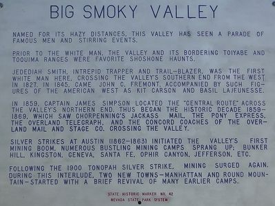
Prior to the white men, the valley and its bordering Toiyabe and Toquima Ranges were favorite Shoshone haunts.
Jedediah Smith, intrepid trapper and trail-blazer, was the first white man here. Crossing the valley's southern end from the west in 1827. In 1845, came John C. Fremont, accompanied by such figures of the American West as Kit Carson and Basil LaJeunesse.
In 1859, Captain James Simpson located the "Central Route" across the valley's northern end. Thus began the historic decade 1859-1869, which saw Chorpenning's Jackass Mail, The Pony Express, The Overland Telegraph, and the Concord Coaches of the Overland Mail and Stage Co. crossing the valley
Silver strikes at Austin (1862-1863) initiated the valley's first mining boom. Numerous bustling mining camps sprang up: Bunker Hill, Kingston, Geneva, Santa Fe, Ophir Canyon, Jefferson, etc.
Following the 1900 Tonopah silver strike, mining surged again. During this interlude, two new towns - Manhattan and Round Mountain - started with a brief revival of many earlier
this page online
Erected by Nevada State Park System. (Marker Number 42.)
Topics and series. This historical marker is listed in this topic list: Settlements & Settlers. In addition, it is included in the Pony Express National Historic Trail series list. A significant historical year for this entry is 1827.
Location. 38° 46.991′ N, 117° 10.517′ W. Marker is in Carvers, Nevada, in Nye County. It is on Nevada Route 376 0.7 miles north of Jefferson Drive, on the left when traveling north. Touch for map. Marker is in this post office area: Round Mountain NV 89045, United States of America. Touch for directions.

Regionally, this marker is in the Mojave Desert and in Central Nevada. It is also in the American Southwest and in the Mountain West. Globally, it is in North America, the Western Hemisphere, the Western World, and the Anglosphere. Historically, it finds itself in what was once New Spain and also Mexico’s Alta California.
Other nearby markers. At least 3 other markers are within 14 miles of this marker, measured as the crow flies: Round Mountain (approx. 5.1 miles away); Ophir (approx. 10.8 miles away); Tate's Stage Station (approx. 13½ miles away).
Credits. This page was last revised on June 16, 2016. It was originally submitted on October 8, 2015, by Trev Meed of Round Mountain, Nevada. This page has been viewed 723 times since then and 60 times this year. Photo 1. submitted on October 8, 2015, by Trev Meed of Round Mountain, Nevada. • Syd Whittle was the editor who published this page.
Editor’s want-list for this marker. PLEASE PROVIDE A WIDE VIEW PHOTO OF THE MARKER AND ITS SURROUNDINGS SHOWING ITS LOCATION IN CONTEXT. • Can you help?
