Near Carvers in Nye County, Nevada — The American Mountains (Southwest)
Tate's Stage Station
1886-1901
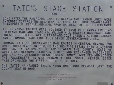
Photographed by Trev Meed, August 28, 2009
1. Tate's Stage Station Marker
The principal routes were covered by such well-known lines as Overland Mail and Stage Co., William Hill Beachey Railroad Stage Lines, Butterfield;s, Wells, Fargo and Co., Pioneer Stageline, Carson and Columbus Stage Line, plus other lesser-known lines.
Thomas Tate sub-contracted mail routes in Central Nevada for over thirty years. In 1868, he and his wife established a station due east as an overnight stop between the county seats of Austin and Belmont. Stages met here and exchanged passengers and mail and obtained fresh horses. Tommy's wife fed and lodged the passengers, in what became a local social center. Ester Tate organized the first school in the area.
The Tates maintained this station until 1901. Belmont lost the county seat in 1905.
Erected by Division of Historic Preservation and Archeology. Myrtle Tate Miles. (Marker Number 217.)
Topics. This historical marker is listed in this topic list: Communications. A significant historical year for this entry is 1886.
Location. 38° 58.701′ N,
this page online

Regionally, this marker is in the Mojave Desert and in Central Nevada. It is also in the American Southwest and in the Mountain West. Globally, it is in North America, the Western Hemisphere, the Western World, and the Anglosphere. Historically, it finds itself in what was once New Spain and also Mexico’s Alta California.
Other nearby markers. At least 2 other markers are within 14 miles of this marker, measured as the crow flies: Ophir (approx. 2.7 miles away); Big Smoky Valley (approx. 13½ miles away).
Credits. This page was last revised on June 16, 2016. It was originally submitted on October 8, 2015, by Trev Meed of Round Mountain, Nevada. This page has been viewed 653 times since then and 60 times this year. Photo 1. submitted on October 8, 2015, by Trev Meed of Round Mountain, Nevada. • Syd Whittle was the editor who published this page.
Editor’s want-list for this marker. PLEASE PROVIDE A WIDE VIEW PHOTO OF THE MARKER AND ITS SURROUNDINGS SHOWING ITS LOCATION IN CONTEXT. • Can you help?
