Tonopah in Nye County, Nevada — The American Mountains (Southwest)
Teamsters
(Photo Captions)
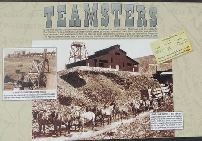
A Horse-Powered Whim Hoist.
is pictured in the foreground. In the distance, the teamster (mounted), swamper (next to wagon), and big team stand ready to take on a load of ore.
Long-Line Hitch or Big Teams:
Large freight wagons, often hitched together, could hold up to ten tons and were pulled by teams of 16, 18, 20 or more animals.
Above:A long-line hitch prepares to load up for the trip to the railhead in 1906. Can you spot where this photo was taken?
Erected by Tonopah Historic Mining Park.
Topics. This historical marker is listed in these topic lists: Industry & Commerce • Settlements & Settlers. A significant historical year for this entry is 1906.
Location. 38° 4.212′ N, 117° 13.778′ W. Marker is in Tonopah, Nevada, in Nye County. Marker can be reached from 110 Burro Avenue. The GPS coordinates are for the Tonopah Mining Park in general. They will not take you directly to the marker. If you are going all the way to Tonopah to see this marker, you might as well walk around and see all the rest too. Touch for map. Marker is in this post office area: Tonopah NV 89049, United States of America. Touch for directions.
Other nearby markers. At least 8 other markers are within walking distance of this marker. The Leasers (here, next to this marker); Stopes (here, next to this marker); Mizpah Mine Powder Magazine (here, next to this marker); Verdi Lumber Company Coal Bin (here, next to this marker); Undiscovered Silver Vein (here, next to this marker); Framing Building (here, next to this marker); Into the Depths (within shouting distance of this marker); The Hoistmen (about 400 feet away, measured in a direct line). Touch for a list and map of all markers in Tonopah.
Credits. This page was last revised on December 13, 2021. It was originally submitted on October 14, 2015, by Trev Meed of Round Mountain, Nevada. This page has been viewed 311 times since then and 11 times this year. Photos: 1. submitted on October 14, 2015, by Trev Meed of Round Mountain, Nevada. 2. submitted on December 12, 2021, by Denise Boose of Tehachapi, California. • Andrew Ruppenstein was the editor who published this page.

