Gananoque in Leeds and Grenville United Counties, Ontario — Central Canada (North America)
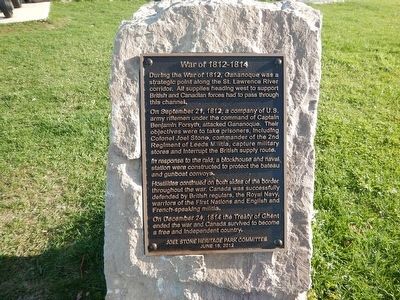
War of 1812-1814
During the war of 1812, Gananoque was a strategic point along the St. Lawrence River corridor. All supplies heading west to support British and Canadian forces had to pass through this channel.
On September 21, 1812, a company of U.S. army rifleman under the command of Captain Benjamin Forsyth, attacked Gananoque. Their objectives were to take prisoners, including Colonel Joel Stone, commander of the 2nd Regiment of Leeds Militia, capture military stores and interrupt the British supply route.
In response to the raid, a blockhouse and naval station were constructed to protect the bateau and gunboat convoys
Hostilities continued on both sides of the border throughout the war. Canada was successfully defended by British regulars, the Royal Navy, warriors of the First Nations and English and French-speaking militia.
On December 24, 1814 the Treaty of Ghent ended the war and Canada survived to become a free and independent country.
Erected 2012 by Joel Stone Heritage Park Committee.
Topics. This historical marker is listed in this topic list: War of 1812. A significant historical year for this entry is 1812.
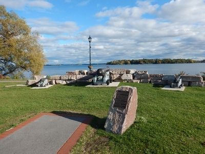
Location. 44° 19.39′ N, 76° 9.724′ W. Marker is in Gananoque, Ontario, in Leeds and Grenville United Counties. Marker is on Water Street west of Market Street, on the left when traveling west. Marker is located in Joel Stone Heritage Park, near the water. Touch for map. Marker is at or near this postal address: 26 Kate Street, Gananoque ON K7G 2M5, Canada. Touch for directions.
Other nearby markers. At least 8 other markers are within walking distance of this marker. War Memorial (here, next to this marker); United Empire Loyalist Joel Stone 1749-1833 (a few steps from this marker); Taming the Wilderness / Domestiquer la Nature (a few steps from this marker); Infrastructure / Infrastructures (a few steps from this marker); River Traffic / Affluence sur la Rivière (a few steps from this marker); The Raid on Gananoque / Le Raid sur la Gananoque (a few steps from this marker); The Garrison Settlement / l’Établissement de la Garnison (a few steps from this marker); A Bright and Prosperous Future / un Avenir Brillant et Prospère (a few steps from this marker). Touch for a list and map of all markers in Gananoque.
Credits. This page was last revised on October 10, 2022. It was originally submitted on October 27, 2015, by Kevin Craft of Bedford, Quebec. This page has been viewed 331 times since then and 8 times this year. Photos: 1, 2. submitted on October 27, 2015, by Kevin Craft of Bedford, Quebec.

