Florence in Omaha in Douglas County, Nebraska — The American Midwest (Upper Plains)
Winter Quarters
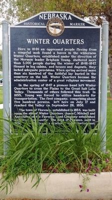
Photographed by Tom Bosse, September 8, 2015
1. Winter Quarters Marker
In the spring of 1847 a pioneer band left Winter Quarters to cross the Plains to the Great Salt Lake Valley. Thousands of others followed this trail. In 1855, Young was forced to utilize handcarts for transportation. The first company, comprising about five hundred persons, left here on July 17 and reached the Valley on September 26, 1856.
The town of Florence, established in 1854 was built upon the site of Winter Quarters. James C. Mitchell and Associates of the Florence Land Company established a thriving community. The Bank of Florence, built in 1856, stands today as a symbol of our historical past.
Erected by Florence Historical Foundation & Historical Land Mark Council. (Marker Number 19.)
Topics and series. This historical marker is listed in these topic lists: Religion & Religious Structures • Settlements & Settlers. In addition, it is included in the Mormon Pioneer Trail, and the Nebraska State Historical Society series lists. A significant historical year for this entry is 1846.
Location. 41° 20.144′ N, 95° 57.625′ W. Marker is in Omaha, Nebraska, in Douglas County. It is in Florence. It is at the intersection of 30th Street and Mormon Street, on the left when traveling north on 30th Street. Touch for map. Marker is in this post office area: Omaha NE 68112, United States of America. Touch for directions.

Regionally,
this page online
Other nearby markers. At least 8 other markers are within walking distance of this marker: The Bank of Florence (about 600 feet away, measured in a direct line); A Little Town That Dreamed of Greatness (about 700 feet away); From Indian Lands to the Golden Gate (about 700 feet away); The Mormon Pioneer Trail / A Meeting House For The Saints (approx. half a mile away); A Meeting House for the Saints (approx. half a mile away); The Florence Mill (approx. half a mile away); The Road to Zion (approx. 0.6 miles away); Crossroads to the West: (approx. 0.6 miles away). Touch for a list and map of all markers in Omaha.
Other markers no longer nearby. Mormon Pioneer Memorial Bridge (was about 600 feet away but has been confirmed missing); a different marker also named The Florence Mill (was approx. half a mile away but
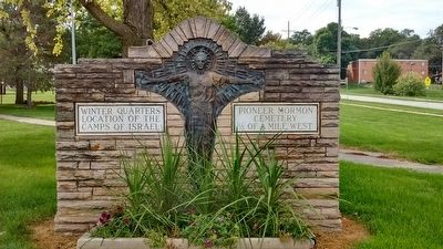
Photographed by Tom Bosse, September 8, 2015
2. Winter Quarters Marker
Credits. This page was last revised on November 20, 2024. It was originally submitted on November 12, 2015, by Tom Bosse of Jefferson City, Tennessee. This page has been viewed 1,027 times since then and 74 times this year. Photos: 1, 2. submitted on November 12, 2015, by Tom Bosse of Jefferson City, Tennessee. • Bill Pfingsten was the editor who published this page.
Editor’s want-list for this marker. A wide shot of the marker and its surroundings. • Can you help?
