Tulia in Swisher County, Texas — The American South (West South Central)
Tulia Depot
Photographed by Bill Kirchner, November 17, 2015
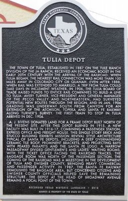
1. Tulia Depot Marker
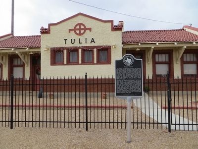
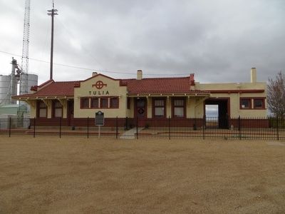
A. J. Bivens donated land for a frame depot built north of the present site. After this depot burned in 1915, a new facility was built in 1916-17, combining a passenger station, express office and freight house. This single-story brick and stucco building exhibits mission revival style architecture typical of Santa Fe depots, including a deep overhanging ceramic tile roof, prominent brackets, and projecting bays with peaked parapets and the Santa Fe logo. A narrow passageway divided gentlemen’s and ladies’ waiting rooms, with the ticket office facing the railroad tracks. The baggage room was north of the passenger section. The coming of the railroad was a milestone in the development of Tulia and Swisher County, bringing heavy commercial and passenger activity. In 1987, the Santa Fe railway demolished the baggage area, but concerned citizens and Swisher county officials helped save the remaining structure. The depot at the head of Broadway Avenue remains a focal point of the town.
Marker is property of the State of Texas
Erected 2010
this page online
Topics and series. This historical marker is listed in this topic list: Railroads & Streetcars. In addition, it is included in the Atchison, Topeka and Santa Fe Railway series list. A significant historical month for this entry is January 1906.
Location. 34° 32.231′ N, 101° 46.655′ W. Marker is in Tulia, Texas, in Swisher County. It is on West Broadway west of Railroad Avenue, on the right when traveling west. Touch for map. Marker is in this post office area: Tulia TX 79088, United States of America. Touch for directions.

Regionally, this marker is on the Texas Panhandle. It is also on the American Great Plains and specifically on the Southern Plains. Globally, it is in North America, a Gulf of Mexico state, the Western Hemisphere, the Western World, and the Anglosphere. Historically, it finds itself in what was once New Spain, the Comanchería, the Dust Bowl, the Republic of Texas, and one of the Confederate States of America.
Other nearby markers. At least 8 other markers are within walking distance of this marker: Quanah Parker Trail (approx. 0.3 miles away); First Methodist Church of Tulia
Photographed by Bill Kirchner, November 17, 2015
2. Tulia Depot Marker
Photographed by Bill Kirchner, November 17, 2015
3. Tulia Depot
Credits. This page was last revised on June 16, 2016. It was originally submitted on December 1, 2015, by Bill Kirchner of Tucson, Arizona. This page has been viewed 1,083 times since then and 115 times this year. Photos: 1, 2, 3. submitted on December 1, 2015, by Bill Kirchner of Tucson, Arizona.
