Near Stonewall in Gillespie County, Texas — The American South (West South Central)
Conserving the Landscape
Lyndon B. Johnson National Historical Park
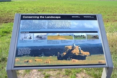
With diligent watering, fertilizing, and cattle rotation, these fields yielded three cuttings of grass each year. Of LBJís nine ranches (most of them larger than the LBJ Ranch), only on this one did he practice intensive conservation. The other ranches were “unimproved” and yielded only one crop of grass each year. Their appearance bore little resemblance to the neat landscape you see here.
(Annual Cycle Photo Captions)
Annual Cycle
February - March: Soil samples taken to determine deficiencies.
April - May: First application of fertilizer, based on soil analysis.
About June 1: Hay is cut for the first time. The grass is fertilized again and irrigated if necessary with water drawn from the Pedernales River.
About July 1: Hay is cut for the second time. Grass is again fertilized and irrigated as needed.
August - November: Cattle rotate into the field to graze down grasses before the first freeze.
December - January: Fields are dormant.
(Bottom Photo Caption)
Of the three crops of grass, ranch hands usually cut one for hay. When the other crops were ready, the hands would rotate cattle through the fields to graze the fields down—a process that usually took 150 head of cattle about a week.
Erected by National Park Service.
Topics and series. This historical marker is listed in this topic list: Agriculture. In addition, it is included in the Former U.S. Presidents: #36 Lyndon B. Johnson series list.
Location. 30° 14.581′ N, 98° 37.167′ W. Marker is near Stonewall, Texas, in Gillespie County. Marker is on Bailey Road, 0.3 miles north of Park Road 49, on the left when traveling north. Marker is located on the LBJ Ranch Driving Tour in Lyndon B. Johnson National Historical Park. Touch for map. Marker is in this post office area: Stonewall TX 78671, United States of America. Touch for directions.
Other nearby markers. At least 8 other markers are within walking distance of this marker. The Environmental President (approx. 0.2 miles away); Low Water Crossing (approx. ľ mile away); Friendship Stones (approx. 0.3 miles away); Lifetime of Service (approx. 0.3 miles away); Communicating with the World (approx. 0.3 miles away); Welcome to the Hangar (approx. 0.3 miles away); The Texas White House (approx. 0.4 miles away); The Jet Age Arrives! (approx. 0.4 miles away). Touch for a list and map of all markers in Stonewall.
Related markers. Click here for a list of markers that are related to this marker. This list consists of 26 wayside exhibits along the LBJ Ranch driving tour in Lyndon B. Johnson NHP. The markers are in order as you would encounter them on the driving tour.
Also see . . .
1. Lyndon B. Johnson National Historical Park - Official Website. (Submitted on December 4, 2015.)
2. Ranching the LBJ Way brochure from the National Park Service. (Submitted on December 4, 2015.)
Credits. This page was last revised on June 16, 2016. It was originally submitted on December 4, 2015, by Duane Hall of Abilene, Texas. This page has been viewed 257 times since then and 9 times this year. Photos: 1, 2, 3. submitted on December 4, 2015, by Duane Hall of Abilene, Texas.


