Marshall in Fauquier County, Virginia — The American South (Mid-Atlantic)
McClellan Relieved From Command
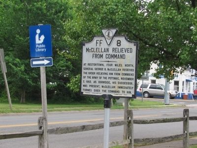
Photographed by Craig Swain, June 16, 2007
1. McClellan Relieved From Command Marker
Erected 1942 by Virginia Conservation Commission. (Marker Number FF-8.)
Topics and series. This historical marker is listed in this topic list: War, US Civil. In addition, it is included in the Virginia Department of Historic Resources (DHR) series list. A significant historical date for this entry is November 7, 1804.
Location. 38° 51.987′ N, 77° 51.273′ W. Marker is in Marshall, Virginia, in Fauquier County. It is at the intersection of East Main Street (John Marshall Highway) (Virginia Route 55) and Rectortown Road ( Route 710), on the right when traveling west on East Main Street (John Marshall Highway). Touch for map. Marker is in this post office area: Marshall VA 20115, United States of America. Touch for directions.

Regionally, this marker is in the Washington Metropolitan Area and in Northern Virginia. It is also in the American South, specifically in the Upper South, and
this page online
Other nearby markers. At least 8 other markers are within 2 miles of this marker, measured as the crow flies: Salem (within shouting distance of this marker); Mosby’s Rangers Disband (about 300 feet away, measured in a direct line); Mosby’s Rangers Disband Site (approx. 0.2 miles away); Campaign of Second Manassas (approx. 0.4 miles away); Lee’s Narrow Escape (approx. 0.4 miles away); Presley Neville O'Bannon (ca. 1776-1850) (approx. 0.9 miles away); Confederate Memorial (approx. 0.9 miles away); Number 18 School (approx. 1.3 miles away). Touch for a list and map of all markers in Marshall.
Another marker is no longer nearby. Birthplace of Lt. Presley Neville O’Bannon, USMC (was approx. 0.9 miles away but has been replaced with another marker now near it).
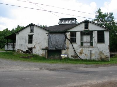
Photographed by Craig Swain, June 16, 2007
2. Rectortown Station
McClellan was camped near this station when the relief message arrived.
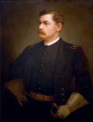
Photographed by Allen C. Browne, November 29, 2015
3. George B. McClellan
This 1888 portrait of George B. McClellan by Julian Scott hangs in the National Portrait Gallery in Washington DC.
“After the Union army's defeat at the First Battle of Manassas on July 21, 1861, President Lincoln appointed thirty-four-year-old General George B. McClellan to command federal operations in Virginia. Within weeks, "little Mac" transformed the remnants of a demoralized volunteer army into a disciplined fighting machine and christened it the Army of the Potomac. But achieving victory required engaging the enemy in battle, and in this McClellan procrastinated, much to Lincoln's exasperation. When he did lead his troops into battle, he was slow to advance and quick to retreat. Finally, after McClellan failed to pursue Robert E. Lee's army following the Union's victory at the Battle of Antietam in September 1862, Lincoln relieved him of his command. McClellan emerged briefly in national politics in 1864 as the Democratic Party's unsuccessful presidential candidate.” — National Portrait Gallery
“After the Union army's defeat at the First Battle of Manassas on July 21, 1861, President Lincoln appointed thirty-four-year-old General George B. McClellan to command federal operations in Virginia. Within weeks, "little Mac" transformed the remnants of a demoralized volunteer army into a disciplined fighting machine and christened it the Army of the Potomac. But achieving victory required engaging the enemy in battle, and in this McClellan procrastinated, much to Lincoln's exasperation. When he did lead his troops into battle, he was slow to advance and quick to retreat. Finally, after McClellan failed to pursue Robert E. Lee's army following the Union's victory at the Battle of Antietam in September 1862, Lincoln relieved him of his command. McClellan emerged briefly in national politics in 1864 as the Democratic Party's unsuccessful presidential candidate.” — National Portrait Gallery
Credits. This page was last revised on June 16, 2016. It was originally submitted on June 17, 2007, by Craig Swain of Leesburg, Virginia. This page has been viewed 2,748 times since then and 66 times this year. Last updated on December 5, 2015, by Allen C. Browne of Silver Spring, Maryland. Photos: 1, 2. submitted on June 17, 2007, by Craig Swain of Leesburg, Virginia. 3. submitted on December 5, 2015, by Allen C. Browne of Silver Spring, Maryland. • Bill Pfingsten was the editor who published this page.
