Sheridan in Sheridan County, Wyoming — The American West (Mountains)
The Black Diamonds of Sheridan County

Photographed By Barry Swackhamer, September 15, 2015
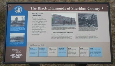
1. The Black Diamonds of Sheridan County Marker
Captions: (top left) The Dietz Mine was the first commercial coal mine in Sheridan County. Image 1903.; (bottom left) As underground mines closed, open pit mining emerged. Image late 1950s.; (center right) The Burlington and Missouri Railroad Depot was built in 1910 and is located at 841 Broadway in Sheridan's Historic Railroad District. Image 2012.; (middle right) The Big Horn Coal transfer station, shown above, was one of the many important railroad stations that transferred coal away from the mines and to regional and national markets. Image c. 1957.
Ranches in Sheridan County accessed outcrops of coal with pick and shovel as early as 1880. Known as "wagon mines" because people loaded the coal directly into wagons, these mines served the local population, providing heat and cooking fuel for homes and businesses.
Full scale development of the area coal mines followed the arrival of the Burlington and Missouri Railroad (part of the Chicago, Burlington and Quincy Railroad) in 1892. The railroad used the coal itself and hauled it to distant markets. The investment and labor needed to build large-scale mines came from outside the region, with over 20 nationalities eventually being represented in the Sheridan County coal mines.
1890s Demand due to industrialization creates boom in coal industry.
1914-1918 World War I - war-time demand creates coal boom.
1921 Coal prices crash as coal is replaced by natural gas.
1939-1945 World War II - war-time demand creates coal boom.
1945 Decades long busy begins as locomotives switch to diesel fuel. Natural gas and oil continue to replace coal.
1953 Last underground mine in Sheridan County closes, first open pit mine opens.
1970s Coal boom returns with oil embargo and continues through 1012 as coal from the Powder River Basin helps to fuel the world.
Erected by Wyoming State Parks & Cultural Resources.
Topics. This historical marker is listed in this topic list: Industry & Commerce.
Location. 44° 48.37′ N, 106° 56.462′ W. Marker is in Sheridan, Wyoming, in Sheridan County. Marker can be reached from Sibley Circle near East 5th Street. Touch for map. Marker is at or near this postal address: 850 Sibley Circle, Sheridan WY 82801, United States of America. Touch for directions.
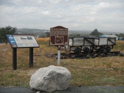
Other nearby markers. At least 8 other markers are within 2 miles of this marker, measured as the crow flies. The Black Diamond Trail (here, next to this marker); The Sheridan Railway Company (about 400 feet away, measured in a direct line); Big Horns (approx. 0.3 miles away); A Place of Shelter (approx. 0.3 miles away); Class 0-5-A Mohawk Locomotive (approx. 0.6 miles away); Historic Sheridan Inn (approx. 0.6 miles away); First Cabin in Sheridan (approx. 0.9 miles away); General George Crook (approx. 1.2 miles away). Touch for a list and map of all markers in Sheridan.
More about this marker. This marker is located at the Sheridan County Museum at the western edge of the parking lot.
This is stop #1 on The Black Diamond Tail. Request a Black Diamonds Trail brochure at the museum or visitors center.
Credits. This page was last revised on June 16, 2016. It was originally submitted on December 11, 2015, by Barry Swackhamer of Brentwood, California. This page has been viewed 280 times since then and 11 times this year. Photos: 1, 2. submitted on December 11, 2015, by Barry Swackhamer of Brentwood, California.
