Near Wildorado in Deaf Smith County, Texas — The American South (West South Central)
Palo Duro Baptist Church
Photographed by Bill Kirchner, November 19, 2015
1. Palo Duro Baptist Church Marker
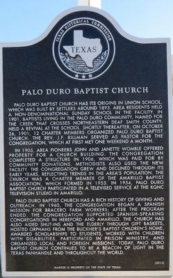
In 1905, area pioneers John and Janette Womble offered property for a church building. The congregation completed a structure in 1906, which was paid for by community donations. Methodists also used the new facility. The congregation grew and declined through its early years, reflecting trends in the area’s population. The church was a charter member of the Amarillo Baptist Association, which formed in 1953. In 1954, Palo Duro Baptist Church participated in a televised service at the KGNC television studio in Amarillo.
Palo Duro Baptist Church has a rich history of giving and outreach. In 1960, the congregation began a Spanish mission for Bracero farm workers; after the program ended, the congregation supported Spanish-speaking congregations in Hereford and Amarillo. The church has also aided shut-ins and the elderly through gift baskets, hosted orphans from the Buckner’s Baptist Children’s Home, awarded scholarships to students, worked with children with disabilities, participated in prison ministry, and organized local and foreign missions. Today, Palo Duro Baptist Church continues to be a beacon of light in the Texas Panhandle and throughout the world.
Erected 2010 by Texas Historical Commission. (Marker Number 16428.)
Topics. This historical marker is listed in this topic list: Religion & Religious Structures. A significant historical date for this entry is October 26, 1901.
Location. 35° 7.039′ N,
this page online

Regionally, this marker is on the Texas Panhandle. It is also on the American Great Plains and specifically on the Southern Plains. Globally, it is in North America, a Gulf of Mexico state, the Western Hemisphere, the Western World, and the Anglosphere. Historically, it finds itself in what was once New Spain, the Comanchería, the Dust Bowl, the Republic of Texas, and one of the Confederate States of America.
Other nearby markers. At least 4 other markers are within 17 miles of this marker, measured as the crow flies: Palo Duro Wildorado Cemetery (within shouting distance of this marker); Umbarger (approx. 12½ miles away); Randall County (approx. 13.1 miles away); Fort Smith-Santa Fe Trail (approx. 16.2 miles away).
Photographed by Bill Kirchner, November 19, 2015
2. Palo Duro Baptist Church Marker
Photographed by Bill Kirchner, November 19, 2015
3. Palo Duro Baptist Church
Credits. This page was last revised on June 16, 2016. It was originally submitted on December 20, 2015, by Bill Kirchner of Tucson, Arizona. This page has been viewed 640 times since then and 38 times this year. Photos: 1, 2, 3. submitted on December 20, 2015, by Bill Kirchner of Tucson, Arizona.
