Eureka in Humboldt County, California — The American West (Pacific Coastal)
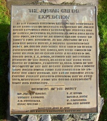
The Josiah Gregg Expedition
After finding Humboldt Bay from the sand dunes near Fairhaven on December 20, 1849, the Dr. Josiah Gregg exploring party reached the present site of Eureka. December 26, passing an open area near this point, to camp by an Indian village close to today’s Fort Humboldt. At the junction of Eel and Van Duzen Rivers, a dispute separated the party. Dr. Gregg and three men tried to reach civilization via the coast, but were forced to turn inland. Near Clear Lake a weakened Dr. Gregg died. L.K. Wood, leading the dissenting members of the party, reached the Mark West Ranch in Sonoma, February 17, 1850. Word of the discovery of the bay became known and a dozen ships raced north from San Francisco to locate the lost harbor. The Laura Virginia Association finally entered Humboldt Bay in April 1850, benefiting from the Gregg Expedition’s work and hardships.
Members of the party:
Dr. Josiah Gregg
Thomas Sabring
J.B. Truesdell
Isaac Wilson
L.K. Wood
David A. Buck
C. Southard
Mr. Van Duzen
Dedicated June 14, 1976 by the Eureka Bicentennial Commission.
Erected 1976 by Eureka Bicentennial Commission.
Topics and series. This historical marker is listed in these topic lists: Exploration • Settlements & Settlers . In addition, it is included in the The Spirit of ’76, America’s Bicentennial Celebration series list. A significant historical date for this entry is February 17, 1850.
Location. 40° 48.118′ N, 124° 9.611′ W. Marker is in Eureka, California, in Humboldt County. Marker is at the intersection of 6th Street and K Street, on the right when traveling west on 6th Street. Touch for map. Marker is at or near this postal address: 1008 6th Street, Eureka CA 95501, United States of America. Touch for directions.
Other nearby markers. At least 8 other markers are within walking distance of this marker. St. Bernard Catholic Church (approx. 0.2 miles away); The Samuel W. McFarland Block (approx. 0.2 miles away); United States Post Office and Courthouse (approx. 0.2 miles away); The Thomas F. Ricks House (approx. ¼ mile away); Masonic Building (1922) (approx. ¼ mile away); The Carson House (approx. ¼ mile away); Pythian Castle (approx. ¼ mile away); Arkley Center for the Performing Arts (approx. ¼ mile away). Touch for a list and map of all markers in Eureka.
Also see . . . Josiah Gregg - Wikipedia. Josiah Gregg's biography by Wikipedia, including details on what was to be his last expedition. (Submitted on December 31, 2015.)
Credits. This page was last revised on June 16, 2016. It was originally submitted on December 31, 2015, by Andrew Ruppenstein of Lamorinda, California. This page has been viewed 623 times since then and 60 times this year. Photos: 1, 2. submitted on December 31, 2015, by Andrew Ruppenstein of Lamorinda, California.

