Superior in Sweetwater County, Wyoming — The American West (Mountains)
Superior
In Dedication

Photographed By Barry Swackhamer, September 9, 2015
1. Superior Marker
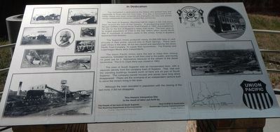
Captions: (left side, left to right then top to bottom) Haul Cars, Loaded Tip, D.O. Clark Mine Tipple, D.O. Clark, Compressed Air Locomotive, Interior Supports,Automatic Coal Shovel, "A" Mine Dump; (right side, top to bottom) Union Seal, Union Hall, Superior Wyoming July 1910, Interstate Map Section, Union Pacific Seal.
The town of Superior, Wyoming had its origins in the coal boom days around the turn of the century. A prospecting team led by Morgan Griffiths entered Horse Thief Canyon in 1900, and established the site for the first of Superior’s many coal mines. The town grew to its largest population of 2,700 in the mid 1940s when, during world War II, hundreds of workers came to the mines, living in quarters fashioned from boxcars.
The Superior mines produced nearly 24,000,000 tons of coal annually in their prime, second only to Rock Springs. There were eight mines in the area, all but two owned and operated by the Union Pacific Coal Company to supply their locomotives. The Premier and Copenhagen Mines were independents. The Union Pacific mines were the last to close their mining operations, forbidden by law to sell their coal to the public, and having no great use for it themselves because of the advent of the diesel locomotive. The D.O. Clark Mine was closed in 1963.
The town of South Superior was an incorporated town, with a separate identity from the company town of Superior. This Hall and the standing buildings located north of here are all part of South Superior. The company-owned houses and stores have long since disappeared. These are the remnants of an independent venture built to serve the miners living in the area.
Erected by The People of the Town of South Superior, The Wyoming Department of Environment, Tern Engineering, Western Wyoming Community College, Noel Griffith & Associates, Sweetwater County Commissioners, Linda Tallifero, Larry Calier and Fred Radosovich.
Topics. This historical marker is listed in these topic lists: Industry & Commerce • Settlements & Settlers. A significant historical year for this entry is 1900.
Location. 41° 45.738′ N, 108° 58.099′ W. Marker is in Superior, Wyoming, in Sweetwater County. Marker can be reached from Main Street (State Highway 371) near Berta Street, on the left when traveling north. Touch for map. Marker is at or near this postal address: 109 Main Street, Superior WY 82945, United States of America. Touch for directions.
Other nearby markers. At least 8 other markers are within 11 miles of this marker, measured as the crow flies. Unions (a few steps from this marker); Opening the Mines (a few steps from this marker); Prospecting (a few steps from this marker); Town Development (a few steps from this marker); Working in the Mines (a few steps from this marker); Immigrants (within shouting distance of this marker); Point of Rocks (approx. 10.8 miles away); An Unsolved Mystery (approx. 10.8 miles away). Touch for a list and map of all markers in Superior.
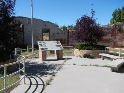
More about this marker. This marker is located at the Miners Union Hall.
Credits. This page was last revised on June 16, 2016. It was originally submitted on January 15, 2016, by Barry Swackhamer of Brentwood, California. This page has been viewed 606 times since then and 7 times this year. Photos: 1, 2. submitted on January 15, 2016, by Barry Swackhamer of Brentwood, California.
