Marker Logo
THE HISTORICAL
MARKER DATABASE
“Bite-Size Bits of Local, National, and Global History”
Miramar in Jacksonville in Duval County, Florida — The American South (South Atlantic)
 

Oriental Gardens
 
 
Oriental Gardens Marker image. Click for full size.
Photographed by Tim Fillmon, June 24, 2015
1. Oriental Gardens Marker
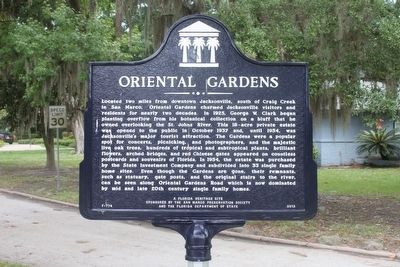
Inscription. Located two miles from downtown Jacksonville, south of Craig Creek in San Marco, Oriental Gardens charmed Jacksonville visitors and residents for nearly two decades. In 1925, George W. Clark began planting overflow from his botanical collection on a bluff that he owned overlooking the St. Johns River. This 18-acre private estate was opened to the public in October 1937 and, until 1954, was Jacksonville's major tourist attraction. The Gardens were a popular spot for concerts, picnicking, and photographers, and the majestic live oak trees, hundreds of tropical and subtropical plants, brilliant flowers, arched bridges, and red Chinese gates appeared on countless postcards and souvenirs of Florida. In 1954, the estate was purchased by the State Investment Company and subdivided into 33 single family home sites. Even though the Gardens are gone, their remnants, such as statuary, gate posts, and original stairs to the river, can be seen along Oriental Gardens Road which is now dominated by mid and late 20th century single family homes.
 
Erected 2013 by The San Marco Preservation Society and the Florida Department of State.
Paid Advertisement
Click or scan to see
this page online
(Marker Number F-774.)
 
Topics. This historical marker is listed in this topic list: Horticulture & Forestry.
 
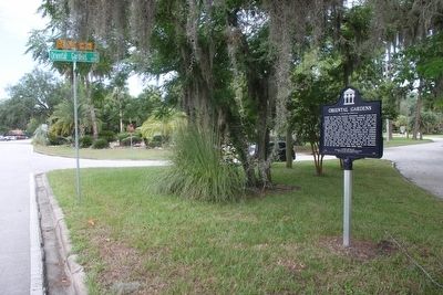
Location. 30° 17.631′ N, 81° 38.918′ W. Marker is in Jacksonville, Florida, in Duval County. It is in Miramar. It is at the intersection of San Jose Boulevard and Oriental Gardens Road, on the right when traveling south on San Jose Boulevard. Touch for map. Marker is in this post office area: Jacksonville FL 32207, United States of America. Touch for directions.

Regionally, this marker is in Florida’s First Coast. It is also in the American South. Globally, it is in the North Atlantic Region, North America, a Gulf of Mexico state, the Western Hemisphere, the Western World, and the Anglosphere. Historically, it finds itself in what was once New Spain, the territory of the Mississippian Culture, one of the Confederate States of America, and the Antebellum South.

Other nearby markers. At least 8 other markers are within 2 miles of this marker, measured as the crow flies: Old Philips Congregational Church (approx. 0.3 miles away); Philips ~ Craig Swamp Cemetery
Oriental Gardens Marker and surrounding area image. Click for full size.
Photographed by Tim Fillmon, June 24, 2015
2. Oriental Gardens Marker and surrounding area
(approx. 0.3 miles away); Villa Alexandria (approx. 0.6 miles away); Douglas Anderson School (approx. Ύ mile away); San Marco (approx. 0.8 miles away); Fort San Nicholas (approx. one mile away); South Jacksonville City Hall (approx. 1.2 miles away); Honor and Remembrance (approx. 1.4 miles away). Touch for a list and map of all markers in Jacksonville.
 
 
Credits. This page was last revised on February 3, 2023. It was originally submitted on March 16, 2016, by Tim Fillmon of Webster, Florida. This page has been viewed 1,202 times since then and 46 times this year. Photos:   1, 2. submitted on March 16, 2016, by Tim Fillmon of Webster, Florida. • Bernard Fisher was the editor who published this page.

m=93100

CeraNet Cloud Computing sponsors the Historical Marker Database.
This website earns income from purchases you make after using our links to Amazon.com. We appreciate your support.
Paid Advertisement
Jul. 7, 2026