Riverton in Barkhamsted in Northwest Hills Region, Connecticut — The American Northeast (New England)
Peoples State Forest
Photographed by Alan M. Perrie, April 8, 2016
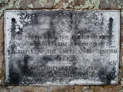
1. Peoples State Forest Marker
was given by the Connecticut
Daughters of the American Revolution
1929
Near this spot was the
site of an Indian Village
Erected 1929 by Daughters of the American Revolution.
Topics and series. This historical marker is listed in these topic lists: Horticulture & Forestry • Indigenous Peoples and Communities • Settlements & Settlers. In addition, it is included in the Daughters of the American Revolution (DAR) series list. A significant historical year for this entry is 1929.
Location. 41° 56.549′ N, 73° 0.433′ W. Marker is in Barkhamsted in Northwest Hills Region, Connecticut. It is in Riverton. It is on East River Road 1.7 miles south of Connecticut Route 20, on the left when traveling south. Touch for map. Marker is in this post office area: Barkhamsted CT 06063, United States of America. Touch for directions.

Regionally, this marker is in the Berkshire Foothills and in the Litchfield Hills. It is also in the American Northeast and in New England. Globally, it is in North America, the Western Hemisphere, the Western World, and the Anglosphere.
this page online
Other nearby markers. At least 8 other markers are within walking distance of this marker: Barkhamsted Lighthouse Village (a few steps from this marker); Barkhamsted Lighthouse Village Cemetery (within shouting distance of this marker); Barkhamsted Lighthouse Village Cellar Holes (about 300 feet away, measured in a direct line); Barkhamsted Lighthouse Village Grind Stone (about 300 feet away); Barkhamsted Lighthouse Village Stone Quarry (about 300 feet away); Barkhamsted Lighthouse Village Charcoal Kilns (about 300 feet away); Camp White (approx. ¼ mile away); Henry Robinson Buck (approx. ¼ mile away). Touch for a list and map of all markers in Barkhamsted.
Regarding Peoples State Forest. Peoples State Forest was established in 1924. Private individuals and citizen groups such as the Daughters of the American Revolution and Connecticut Federation of Women’s Clubs purchased the land by subscription and collectively donated it to the state to be used as a “forest for the People”
James Chaugham (a Native
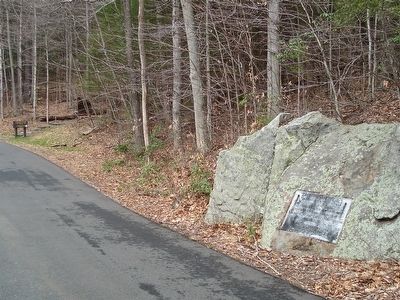
Photographed by Alan M. Perrie, April 8, 2016
2. The Lighthouse Trail sign to the Indian Village
The Indians of Barkhamsted
Barkhamsted Historical Society website entry
Click for more information.
lived in a village near this marker for 50 years. It became Peoples State Forest. People of African and European origin, as well as Native Americans, moved into what became a thriving multi-ethnic and multicultural village. The Chaugham descendants remained until the village was abandoned in 1860.
The name “Barkhamsted Lighthouse” comes from the light from the home fires that could be seen from the nearby stagecoach line. It was a good place to stop since the horses could be watered and the passengers could rest. It became a local landmark.
Also see . . .
1. Peoples State Forest. Connecticut website entry (Submitted on April 12, 2016, by Alan M. Perrie of Unionville, Connecticut.)
2. Barkhamsted Lighthouse. Wikipedia entry. (Submitted on September 30, 2020, by Larry Gertner of New York, New York.)
3. “Outcasts” Build Their Own Village in 18th-Century Barkhamsted. Connecticut History website entry (Submitted on April 12, 2016, by Alan M. Perrie of Unionville, Connecticut.)
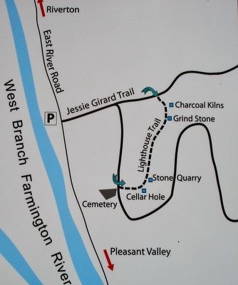
Photographed by Alan M. Perrie, April 8, 2016
3. The Lighthouse Trail map
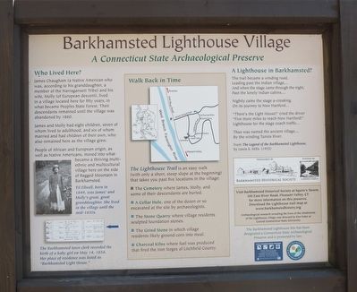
Photographed by Alan M. Perrie, April 8, 2016
4. Barkhamsted Lighthouse Village
Credits. This page was last revised on May 19, 2026. It was originally submitted on April 12, 2016, by Alan M. Perrie of Unionville, Connecticut. This page has been viewed 966 times since then and 40 times this year. Photos: 1, 2, 3, 4. submitted on April 12, 2016, by Alan M. Perrie of Unionville, Connecticut. • Bill Pfingsten was the editor who published this page.
