Jamestown in Chautauqua County, New York — The American Northeast (Mid-Atlantic)
De Longueuil Expedition
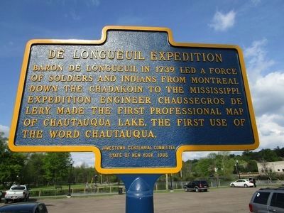
Photographed by Anton Schwarzmueller, May 22, 2016
1. De Longueuil Expedition Marker
River in background. The American Revolution marker is between the black and the white cars.
Erected 1986 by Jamestown Historical Marker Committee.
Topics. This historical marker is listed in this topic list: Exploration. A significant historical year for this entry is 1739.
Location. 42° 5.95′ N, 79° 15.206′ W. Marker is in Jamestown, New York, in Chautauqua County. It is on Jones and Gifford Avenue 0.1 miles north of Fairmount Avenue, on the right when traveling north. Touch for map. Marker is at or near this postal address: 18 Jones and Gifford Avenue, Jamestown NY 14701, United States of America. Touch for directions.

Regionally, this marker is in Upstate New York, specifically in Western New York, and in the Southern Tier. It is also in the American Northeast, in the Mid-Atlantic, in Appalachia, and specifically in Northern Appalachia. Globally, it is in North America, on the Great Lakes, in the Western Hemisphere, in the Western
this page online
Other nearby markers. At least 8 other markers are within walking distance of this marker: American Revolution (within shouting distance of this marker); Celoron Expedition (about 300 feet away, measured in a direct line); Steamboat Landing (about 300 feet away); Log Cabin 1810 (about 400 feet away); Broadhead Power House (about 500 feet away); The First Metal Furniture Factory (about 700 feet away); The Car Barns (approx. 0.3 miles away); West Third Street Bridge (approx. 0.3 miles away). Touch for a list and map of all markers in Jamestown.
More about this marker. Marker is at McCrea Point Riverfront Recreation Area as are several others. Marker had been temporarily removed due to construction, and at the time of this posting on the HMdb, the marker is not seen on Google maps. Due to road construction and configuration, access to McCrea Point is from West 8th Street and the Fairmount Avenue bridge.
Also see . . . Charles III Le Moyne - Wikipedia.
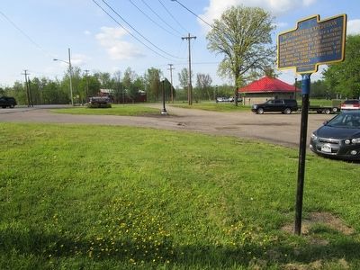
Photographed by Anton Schwarzmueller, May 22, 2016
2. De Longueuil Expedition Marker Site
Northward. Jones and Gifford Avenue at left. Marker is at the McCrea Point Riverfront Recreation Area.
Credits. This page was last revised on June 16, 2016. It was originally submitted on May 23, 2016, by Anton Schwarzmueller of Wilson, New York. This page has been viewed 666 times since then and 43 times this year. Photos: 1, 2. submitted on May 23, 2016, by Anton Schwarzmueller of Wilson, New York.
