Union City in Branch County, Michigan — The American Midwest (Great Lakes)
Indigenous Residents
Union City Heritage Water Trail

Photographed By Val Rossman, June 17, 2016
1. Indigenous Residents Marker
Union City Heritage Water Trail website entry #24
Click for more information.
Click for more information.
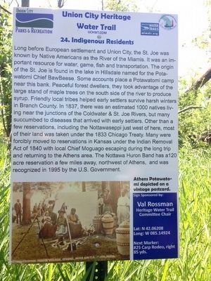
Long before European settlement and Union City, the St. Joe was known by Native Americans as the River of the Miamis. It was an important resource for water, game, fish and transportation. The origin of the St. Joe is found in the lake in Hillsdale named for the Potawatomi Chief BawBeese. Some accounts place a Potawatomi camp near this bank. Peaceful forest dwellers, they took advantage of the large stand of maple trees on the south side of the river to produce syrup. Friendly local tribes helped early settlers survive harsh winters in Branch County. In 1837, there was an estimated 1000 natives living near the junctions of the Coldwater & St. Joe Rivers, but many succumbed to diseases that arrived with early settlers. Other than a few reservations, including the Nottawaseppi just west of here, most of their land was taken under the 1833 Chicago Treaty. Many were forcibly moved to reservations in Kansas under the Indian Removal Act of 1840 with local Chief Moguago escaping during the long trip and returning to the Athens area. The Nottawa Huron Band has a 120 acre reservation a few miles away, northwest of Athens, and was recognized in 1995 by the U.S. Government.
Erected 2016 by Union City Heritage Water Trail. (Marker Number 24.)
Topics and series. This historical marker is listed in these topic lists: Native Americans • Settlements & Settlers. In addition, it is included in the Michigan - Union City Heritage Water Trail series list. A significant historical year for this entry is 1837.
Location. 42° 3.725′ N, 85° 8.954′ W. Marker is in Union City, Michigan, in Branch County. This marker is on private property please do not attempt to access it by trespassing on foot. It is meant to be viewed by paddling the St. Joseph River as part of the Union City Heritage Water Trail. It is on the south bank of the St Joseph river down river from the Park Street Bridge. Touch for map. Marker is in this post office area: Union City MI 49094, United States of America. Touch for directions.
Other nearby markers. At least 8 other markers are within walking distance of this marker. Carp Rodeo (about 300 feet away, measured in a direct line); Elkhorn Lodge: Home of "Skinny" Bullock (about 500 feet away); Gerald Davison's Hilltop House (approx. ¼ mile away); Head of St. Joe Navigation (approx. 0.3 miles away); Alumni Field (approx. 0.4 miles away); The Arbogast Bridge (approx. 0.4 miles away); "Municipal Pond" Becomes Union Lake (approx. half a mile away); The Park Street "Spencer" Bridge (approx. 0.6 miles away). Touch for a list and map of all markers in Union City.
More about this marker. There are 28 of these markers comprising the Union City Heritage Water Trail on the Coldwater River and the St. Joseph River launched in 2016 for the village's Sesquicentennial. These markers can be viewed by paddling the 5 mile stretch of river from the JP Palmer Launch in the Village of Union City to the Riley Dam on the SW Corner of Union Lake. Most of these markers CANNOT by accessed by foot as they are on private property along the river. Please do not trespass. More details can be found at www.uchwt.com
Credits. This page was last revised on April 9, 2022. It was originally submitted on June 17, 2016, by Val Rossman of Union City, Michigan. This page has been viewed 308 times since then and 18 times this year. Photo 1. submitted on June 17, 2016, by Val Rossman of Union City, Michigan. • Bill Pfingsten was the editor who published this page.