Near Bessemer Bend in Natrona County, Wyoming — The American West (Mountains)
And On the Horizon...
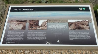
Independence Rock
Independence Rock is an isolated dome of the same composition as the mountains that flank the Sweetwater River Valley. Polished by ancient winds, it rises near the first point of contact with the river for emigrants following the westward trails. Jesuit priest Father Pierre-Jean De Smet in 1840 designated this landmark as "the Great Register of the Desert" for the many carved names that adorned its flanks. While various explanations for the name "Independence Rock" occur in emigrant diaries, some sources attribute it to William Sublette's trading party, which stopped at the site on July 4, 1830.
Devil's Gate
Six miles west and within site of Independence Rock is a dramatic cleft in the granite mountains shadowing the Sweetwater River. Known as Devil's Gate, the narrow passage at its base allows only room enough for the stream to force its way through as it flows toward the North Platte River, with no accommodation for wagons along its sheer rocky banks. The emigrant trails pass by to the south of Devil's Gate. Its name is attributed by early travelers to John C. Fremont, who ascended and mapped the North Platte and Sweetwater Rivers with guide Kit Carson in 1842.
Split Rock
The work of glaciers, wind, weather extremes, and flowing water created the Sweetwater River Valley over hundreds of centuries. Granite cliffs that are visible today on either side of the meandering stream became rounded and worn by these relentless geologic forces and sandy soils resulted from their erosion. Landmarks along the trail of Westward migration are identified for modern highway travelers within view of the Sweetwater River. Shown above is Split Rock, first photographed by William Henry Jackson in 1870. Its distinctive outline is visible for miles in all directions.
Erected by U.S. Department of the Interior, Bureau of Land Management.
Topics and series. This historical marker is listed in these topic lists: Natural Features • Settlements & Settlers. In addition, it is included in the Oregon Trail series list.
Location. 42° 39.619′ N, 106° 48.626′ W. Marker is near Bessemer Bend, Wyoming, in Natrona County. Marker is on Oregon Trail Road (County Route 319) near County Route 308, on the right when traveling
south. Touch for map. Marker is in this post office area: Casper WY 82604, United States of America. Touch for directions.
Other nearby markers. At least 8 other markers are within 14 miles of this marker, measured as the crow flies. Lure of the West (a few steps from this marker); A Look Back (within shouting distance of this marker); Marking Their Progress (within shouting distance of this marker); Willow Springs (approx. 1.3 miles away); Alcova Reservoir (approx. 7˝ miles away); Pathfinder Dam Construction (approx. 8.1 miles away); Fremont Canyon Power Plant (approx. 13.1 miles away); Fremont Canyon (approx. 13.1 miles away). Touch for a list and map of all markers in Bessemer Bend.
More about this marker. This marker is located at Ryan (Prospect) Hill BLM Interpretive Site. The Site is about 13 miles southwest of Casper. From the town of Mills, take Poison Spider Road to county road 319. or from Bessemer Bend take county road 308. Note that CR 308 turns right where CR 314 continues straight. Alternatively, from Alcova, take the Oregon Trail Road (CR319) north from Wyoming Highway 220 for about 8 miles.
Credits. This page was last revised on July 3, 2016. It was originally submitted on July 3, 2016, by Barry Swackhamer of Brentwood, California. This page has been viewed 297 times since then and 10 times this year. Photos: 1, 2, 3. submitted on July 3, 2016, by Barry Swackhamer of Brentwood, California.


