Blowing Rock in Watauga County, North Carolina — The American South (South Atlantic)
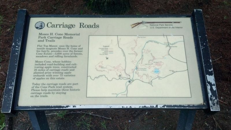
Carriage Roads
Moses H. Cone Memorial Park Carriage Roads and Trails
Photographed by Michael C. Wilcox, August 8, 2013
1. Carriage Roads Marker
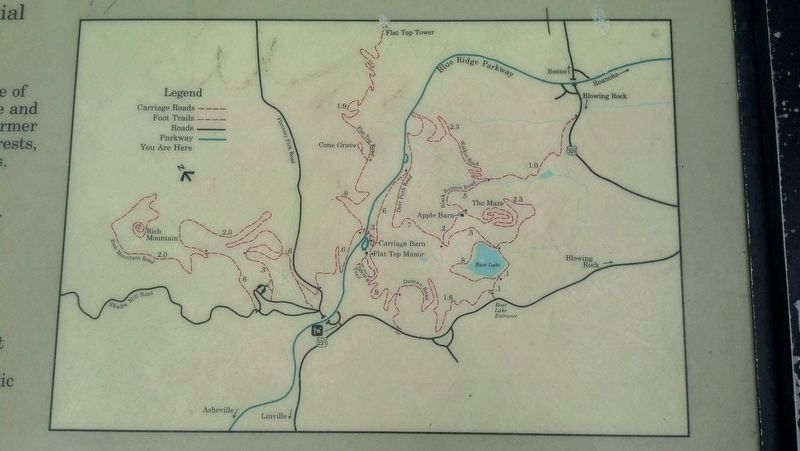
Moses Cone, whose hobbies included road-building and cultivating apple trees, constructed 25 miles of carriage roads and planted prize winning apple orchards with over 75 varieties of apples on this estate.
Today the carriage roads are part of the Cone Park trail system. Please help maintain these historic carriage roads by staying on the trails.
Erected by National Park Service, U.S. Department of the Interior.
Topics. This historical marker is listed in these topic lists: Industry & Commerce • Roads & Vehicles • Settlements & Settlers.
Location. 36° 8.458′ N, 81° 41.215′ W. Marker is in Blowing Rock, North Carolina, in Watauga County. It is on Bass Lake Drive 0.2 miles north of Blowing Rock Highway (U.S. 221), on the right when traveling north. Touch for map. Marker is in this post office area: Blowing Rock NC 28605, United States of America. Touch for directions.

Regionally,
this page online
Other nearby markers. At least 8 other markers are within walking distance of this marker: L.M. Tate Show Grounds (approx. 0.4 miles away); Chetola (approx. 0.6 miles away); Religious Heritage (approx. 0.6 miles away); Medical Care (approx. 0.6 miles away); Philanthropy (approx. 0.6 miles away); Ski Industry (approx. 0.6 miles away); The Blue Ridge Parkway (approx. 0.6 miles away); Tourism (approx. 0.6 miles away). Touch for a list and map of all markers in Blowing Rock.
More about this marker. There is an identical marker at Cone "Flat Top" Manor (at the top of the hill, if you're hiking).
Related marker.
Photographed by Michael C. Wilcox, August 8, 2013
2. Carriage Roads Marker
Photographed by Michael C. Wilcox, August 8, 2013
3. Carriage Roads Marker
Photographed by Michael C. Wilcox, August 8, 2013
4. Carriage Roads Marker
Credits. This page was last revised on October 14, 2016. It was originally submitted on October 13, 2016, by Michael C. Wilcox of Winston-Salem, North Carolina. This page has been viewed 494 times since then and 17 times this year. Photos: 1, 2, 3, 4. submitted on October 13, 2016, by Michael C. Wilcox of Winston-Salem, North Carolina. • Bernard Fisher was the editor who published this page.
