Near Macon in Monroe County, Georgia — The American South (South Atlantic)
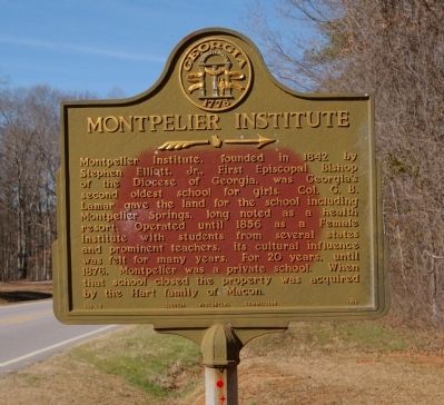
Montpelier Institute
Erected 1955 by Georgia Historical Commission. (Marker Number 102-3.)
Topics and series. This historical marker is listed in these topic lists: Churches & Religion • Education • Women. In addition, it is included in the Georgia Historical Society series list. A significant historical year for this entry is 1842.
Location. 32° 51.906′ N, 83° 52.921′ W. Marker is near Macon, Georgia, in Monroe County. Marker is on Thomaston Road (Georgia Route 74) ¼ mile west of Lower Thomaston Road, on the right when traveling west. Marker is one mile west of the Bibb County line on GA Highway 74. Touch for map. Marker is in this post office area: Forsyth GA 31029, United States of America. Touch for directions.
Other nearby markers. At least 8 other markers are within 12 miles of this marker, measured as the crow flies . William Bartram Trail (approx. 7.4 miles away); a different marker also named William Bartram Trail (approx. 9.4 miles away); The Candler Building (approx. 9.7 miles away); Wesleyan College Historic District (approx. 9.7 miles away); Villa Albicini (approx. 9.9 miles away); State Teachers and Agricultural College / Hubbard Training School (approx. 11.8 miles away); Crawford County (approx. 11.8 miles away); Joanna Troutman (approx. 11.8 miles away). Touch for a list and map of all markers in Macon.
Credits. This page was last revised on January 31, 2020. It was originally submitted on August 4, 2008, by David Seibert of Sandy Springs, Georgia. This page has been viewed 1,615 times since then and 34 times this year. Photo 1. submitted on August 4, 2008, by David Seibert of Sandy Springs, Georgia. • Christopher Busta-Peck was the editor who published this page.
Editor’s want-list for this marker. A wide shot of the marker and its surroundings. • Can you help?
