Gardnerville in Douglas County, Nevada — The American Mountains (Southwest)
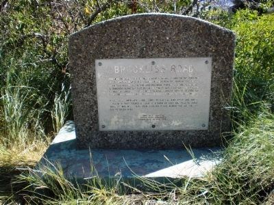
Brockliss Road
Centerville, comprising a bar opened by Chris Berning in 1902 and a blacksmith shop opened by John C. Rieman in 1903 and sold to Parks Brothers who moved here from Sheridan in 1901, marked the eastern end of Brockliss Road.
Carson Valley Marker No. 1
Douglas County Commissioners
Carson Valley Historical Society
N.S.P. 6-23-71
Erected 1971 by Douglas County Commissioners and the Carson Valley Historical Society. (Marker Number 1.)
Topics. This historical marker is listed in this topic list: Roads & Vehicles. A significant historical month for this entry is October 1894.
Location. 38° 54.622′ N, 119° 46.773′ W. Marker is in Gardnerville, Nevada, in Douglas County. Marker is at the intersection of Centerville Lane (Nevada Route 756) and Nevada Highway 88, on the left when traveling west on Centerville Lane . Touch for map. Marker is in this post office area: Gardnerville NV 89460, United States of America. Touch for directions.
Other nearby markers. At least 8 other markers are within 3 miles of this marker, measured as the crow flies. Sheridan (approx. 2.6 miles away); Farmer’s Telephone Company (approx. 2.6 miles away); Record Courier Building (approx. 2.6 miles away); Ritchford Hotel (approx. 2.7 miles away); J & T Basque Restaurant Building (approx. 2.7 miles away); Sharkey's Nugget (approx. 2.7 miles away); Arendt Jensen Merchandise (approx. 2.7 miles away); Adaven Building (approx. 2.7 miles away). Touch for a list and map of all markers in Gardnerville.
More about this marker. The marker/monument is on the southwest corner of intersection of Highway 88 and Centerville Lane.
Credits. This page was last revised on October 15, 2020. It was originally submitted on August 28, 2008, by Andrew Ruppenstein of Lamorinda, California. This page has been viewed 1,441 times since then and 20 times this year. Photos: 1, 2. submitted on August 28, 2008, by Andrew Ruppenstein of Lamorinda, California. • Kevin W. was the editor who published this page.

