Apgar in Flathead County, Montana — The American West (Mountains)
Choosing a Route
Inscription.
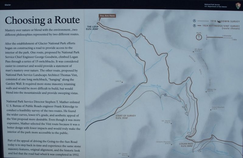
Mastery over nature or blend with the environment...two different philosophies represented by two different routes.
After the establishment of Glacier National Park efforts began on constructing a road to provide access to the interior of the park. One route, proposed by National Park Service Chief Engineer George Goodwin, climbed Logan Pass through a series of 15 switchbacks. It was considered easier to construct and would provide a statement of man’s mastery over nature. The other route, proposed by National Park Service Landscape Architect Thomas Vint, consisted of one long switchback, “hanging” along the Garden Wall. It required more stone masonry retaining walls and would be more difficult to build, but would blend into the mountainside and provide sweeping vistas.
National Park Service Director Stephen T. Mather enlisted U. S. Bureau of Public Roads engineer Frank Kittredge to conduct a feasibility survey of the two routes. He found the wider curves, lower 6% grade, and aesthetic appeal of the Vint proposal more desirable. Even though it was more expensive, Mather selected the Vint route because it was a better design with fewer impacts and would truly make the interior of the park more accessible to the public.
Part of the appeal of driving the Going-to-the-Sun Road today is to step back in time and experience the same stone masonry features, original alignment, and the historic look and feel that the road had when it was completed in 1932.
Erected by National Park Service.
Topics. This historical marker is listed in this topic list: Roads & Vehicles. A significant historical year for this entry is 1918.
Location. 48° 45.289′ N, 113° 48.019′ W. Marker is in Apgar, Montana, in Flathead County. Marker is on Going-to-the-Sun Highway (Closed in Winter). Marker is in pullout at the outside curve of hairpin turn (on right side for downhill traffic). Across from The Loop trail head. Touch for map. Marker is in this post office area: West Glacier MT 59936, United States of America. Touch for directions.
Other nearby markers. At least 8 other markers are within 11 miles of this marker, measured as the crow flies. Stephen Tyng Mather (approx. 5.6 miles away); Horns (approx. 5.6 miles away); Motoring In (approx. 6.3 miles away); Overnight in the Wilderness (approx. 7.2 miles away); When the Glaciers Melt (approx. 7.2 miles away); Historic Boats (approx. 10.1 miles away); Wilderness Architecture (approx. 10.2 miles away); Time Machines (approx. 10.2 miles away).
Credits. This page was last revised on October 6, 2017. It was originally submitted on September 29, 2017, by Christopher Earle of Olympia, Washington. This page has been viewed 255 times since then and 23 times this year. Photo 1. submitted on September 29, 2017, by Christopher Earle of Olympia, Washington. • Syd Whittle was the editor who published this page.
Editor’s want-list for this marker. Wide area view of the marker and its surroundings. • Photo of a full close-up view of the marker. • Can you help?
