Near Gibbonsville in Lemhi County, Idaho — The American West (Mountains)
Lost Trail Pass
Inscription.
Two adjacent markers which complement each other are treated as one marker.
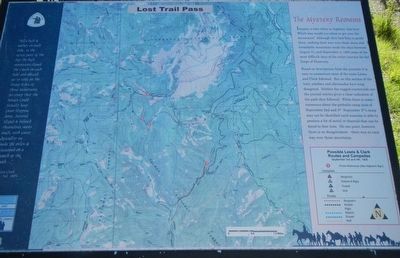
“hills high & rockey on each Side, in the after part of the day the high mountains closed the Creek on each Side and obliged us to take on the Steep Sides of those Mountains, So steep that the horses could scarcely keep from slipping down, several sliped (sic) & injured themselves verry (sic) much, with great dificuelty (sic) we made (8) miles & Encamped on a branch of the Creek. . . “ -- Captain Clark, Sept. 3rd, 1805
Imagine a time when no highway was here. Which way would you chose to get over the mountains? Although they had Toby to guide them, making their way over these steep and formidable mountains made the days between August 31, and September 4, 1805 some of the most difficult days of the entire journey for the Corps of Discovery.
Based on descriptions from the journals it is easy to reconstruct most of the route Lewis and Clark followed. But on this section of the trail, scholars and aficionados have long disagreed. Neither the rugged countryside nor the journal entries gives a clear indication of the path they followed. While there is some consensus about the probable camp sites of September 2nd and 4th September 3rd’s camp may not be identified until someone is able to produce a bit of metal or charcoal that can be dated to that time. On one point, however, there is no disagreement - there was no easy way over these mountains.
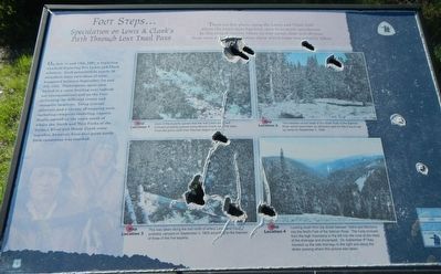
There are few places along the Lewis and Clark trail where the exact route has been open to so much speculation. In this rugged country where no way seems clear and obvious, there were a variety of theories about which route was actually taken.
On July 11 and 12th, 1997, a workshop was held featuring five Lewis and Clark scholars. Each presented to nearly 70 attendees their own ideas of what happened between September 1st and 4th, 1805. Participants spent time locked in a room battling over individual interpretations and on the Pass reviewing the different routes and campsite locations. Using journal accounts and a variety of mapping tools, including computer modeling, experts finally agreed on the route south of where the North and West Forks of the Salmon River and Moose Creek come together, however, from that point north little consensus was reached.
Erected by U.S. Forest Service.
Topics and series. This historical marker is listed

Photographed By Barry Swackhamer, June 24, 2017
2. Foot Steps... Marker
Captions: (top left) Map Location 1 Most of the experts agreed that the trail Lewis and Clark followed probably passed along Moose Creek near this area. From this point north their theories began to diverge.; (top right) Map Location 2 This meadow at the end of the North Fork of the Salmon River would have been an attractive spot for the Corp to set up camp on September 3, 1805.; (bottom left) Map Location 3 This was taken along the trail north of where Lewis and Clark probably camped on September 3, 1805 according to the theories of three of the five experts.; (bottom right) Map Location 4 Looking south from the divide between, Idaho and Montana into the North For of the Salmon River. The Corp crossed from the high mountains to the left into the cove at the head of the drainage and encamped. On September 4th they traveled up the side drainage to the right and along the divide passing where this picture was taken.
Location. 45° 40.976′ N, 113° 56.672′ W. Marker is near Gibbonsville, Idaho, in Lemhi County. Marker is on Casey Road (State Highway 93 at milepost 349) near State Highway 43, on the left when traveling north. Touch for map. Marker is in this post office area: Gibbonsville ID 83463, United States of America. Touch for directions.
Other nearby markers. At least 8 other markers are within 10 miles of this marker, measured as the crow flies. Jerry Fahey’s Cutoff (within shouting distance of this marker); Which Way Did Lewis & Clark Go? (approx. 0.8 miles away in Montana); Salmon River Scenic Byway (approx. 0.8 miles away in Montana); Lewis and Clark (approx. 2.2 miles away); Deep Creek (approx. 6.3 miles away); Natural Travel Corridor (approx. 6.6 miles away in Montana); A Story of Fires... to be continued (approx. 8.2 miles away in Montana); Gibbonsville (approx. 9.7 miles away). Touch for a list and map of all markers in Gibbonsville.
Credits. This page was last revised on September 22, 2018. It was originally submitted on November 5, 2017, by Barry Swackhamer of Brentwood, California. This page has been viewed 390 times since then and 29 times this year. Photos: 1, 2. submitted on November 5, 2017, by Barry Swackhamer of Brentwood, California. 3. submitted on September 21, 2018, by Barry Swackhamer of Brentwood, California.

