Near Pine Mountain Valley in Harris County, Georgia — The American South (South Atlantic)
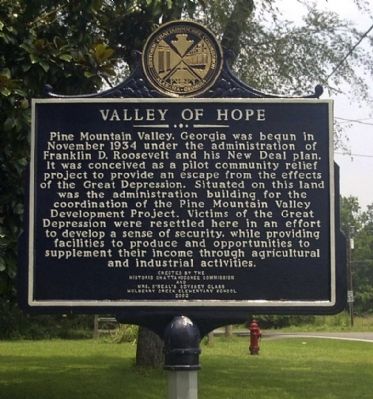
Valley of Hope
Erected 2002 by Historic Chattahoochee Commission and Mrs. O'Neal's Odyssey Class Mulberry Creek Elementary School.
Topics and series. This historical marker is listed in these topic lists: Agriculture • Charity & Public Work. In addition, it is included in the Former U.S. Presidents: #32 Franklin D. Roosevelt series list. A significant historical month for this entry is November 1934.
Location. 32° 47.698′ N, 84° 49.685′ W. Marker is near Pine Mountain Valley, Georgia, in Harris County. Marker is at the intersection of State Highway 116 and K Street, on the left when traveling east on State Highway 116. Touch for map. Marker is at or near this postal address: 13159 Ga Highway 116, Pine Mountain GA 31822, United States of America. Touch for directions.
Other nearby markers. At least 8 other markers are within 4 miles of this marker, measured as the crow flies. Pine Mountain Valley Resettlement Project (approx. half a mile away); Callaway Gardens (approx. 2.3 miles away); The J.L. Hand Gazebo (approx. 2.9 miles away); Pioneer Log Cabin (approx. 3 miles away); Smokehouse (approx. 3 miles away); Franklin D. Roosevelt Memorial Bridge (approx. 3.3 miles away); Carver High School (approx. 3.6 miles away); Harris County (approx. 3.7 miles away).
Credits. This page was last revised on January 4, 2020. It was originally submitted on September 8, 2008, by David Seibert of Sandy Springs, Georgia. This page has been viewed 1,768 times since then and 43 times this year. Photos: 1. submitted on September 8, 2008, by David Seibert of Sandy Springs, Georgia. 2. submitted on September 13, 2009, by David Seibert of Sandy Springs, Georgia. • Kevin W. was the editor who published this page.

