Franklin in St. Mary Parish, Louisiana — The American South (West South Central)
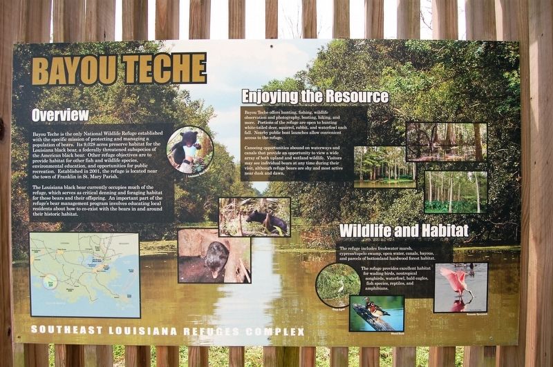
Bayou Teche
Southeast Louisiana Refuges Complex
Bayou Teche is the only National Wildlife Refuge established with the specific mission of protecting and managing a population of bears. Its 9,028 acres preserve habitat for the Louisiana black bear, a federally threatened subspecies of the American black bear.Other refuge objectives are to provide habitat for other fish and wildlife species, environmental education, and opportunities for public recreation. Established in 2001, the refuge is located near the town of Franklin in St. Mary Parish.
The Louisiana black bear currently occupies much of the refuge, which serves as critical denning and foraging habitat for these bears and their offspring. An important part of the refuge's bear management program involves educating local residents about how co-exist with the bears in and around their historical habitat.
Bayou Teche offers hunting, fishing, wildlife observation and photography, boating, hiking, and more. Portions of the refuge are open to hunting white-tail deer, squirrel, rabbit, and waterfowl each fall. Nearby public boat launches allow convenient access to the refuge.
Canoeing opportunities abound on waterways and canals that provide an opportunity to view a wide array of both upland and wetland wildlife. Visitors may see individual
bears at any time during their visit, although refuge bears are shy and most active near dusk and dawn.The refuge includes freshwater marsh, cypress/tupelo swamp, open water, canals, bayous ans parcels of bottomland hardwood forest habitat.
The refuge provides excellent habitat for wading birds, neotropical songbirds, waterfowl, bald eagles, fish species, reptiles, and amphibians.
Topics. This historical marker is listed in these topic lists: Environment • Natural Resources.
Location. 29° 44.414′ N, 91° 27.186′ W. Marker is in Franklin, Louisiana, in St. Mary Parish. Marker is at the intersection of Levee Road and Alice C Road, on the right when traveling west on Levee Road. Touch for map. Marker is in this post office area: Franklin LA 70538, United States of America. Touch for directions.
Other nearby markers. At least 8 other markers are within 5 miles of this marker, measured as the crow flies. A different marker also named Bayou Teche (here, next to this marker); Swamps on the Cusp of Change (about 500 feet away, measured in a direct line); Cypress Trees (about 700 feet away); Murphy James Foster (approx. 3.2 miles away); Franklin's Historic Lampposts (approx. 4.1 miles away); Edward V. Loustalot (approx. 4˝ miles away); St. Mary Parish Courthouse War Memorial (approx. 4˝ miles away); St. Mary Parish Confederate Soldiers Monument (approx. 4˝ miles away). Touch for a list and map of all markers in Franklin.
Credits. This page was last revised on September 3, 2022. It was originally submitted on March 17, 2018, by Cajun Scrambler of Assumption, Louisiana. This page has been viewed 239 times since then and 5 times this year. Photos: 1, 2. submitted on March 17, 2018.

