Monroe in Benton County, Oregon — The American West (Northwest)
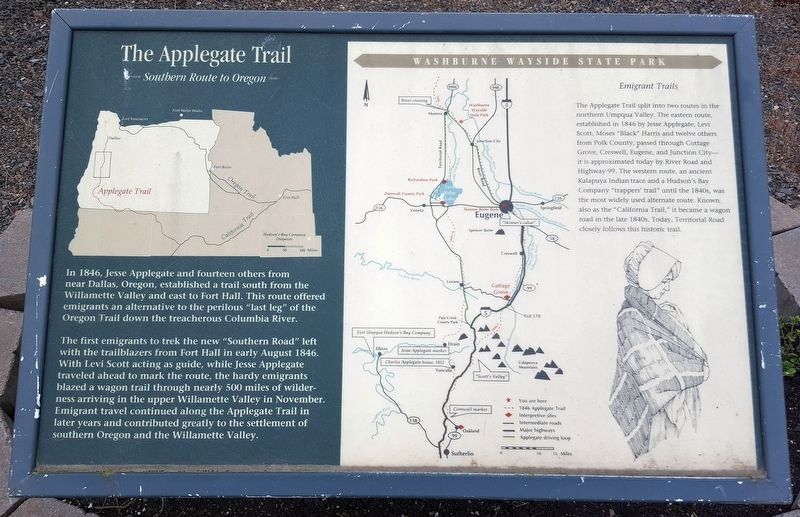
The Applegate Trail
Southern Route to Oregon
(First Display)
In 1846, Jesse Applegate and fourteen others from near Dallas, Oregon, established a trail south from the Willamette Valley and east to Fort Hall. This route offered emigrants an alternative to the perilous “last leg” of the Oregon Trail down the treacherous Columbia River.
The first emigrants to trek the new “Southern Road” left with the trailblazers from Fort Hall in early August 1846. With Levi Scott acting as guide, while Jesse Applegate traveled ahead to mark the route, the hardy emigrants blazed a wagon trail through nearly 500 miles of wilderness arriving in the upper Willamette Valley in November. Emigrant travel continued along the Applegate Trail in later years and contributed greatly to the settlement of southern Oregon and the Willamette Valley.
Emigrant Trails
The Applegate Trail spit into two routes in the northern Umpqua Valley. The eastern route, established in 1846 by Jesse Applegate, Levi Scott, Moses “Black” Harris and twelve others from Polk County, Passed through Cottage Grove, Creswell, Eugene, and Junction City—It is approximated today by River Road and Highway 99. The western route, an ancient Kalapuya Indian trace and a Hudson’s Bay Company “trapper’s trail” until the 1840s, was the most widely used alternate route. Known also as the “California Trail,” it became a wagon road in the late 1840s. Today, Territorial Road closely follows this historic trail.
(Second Display)
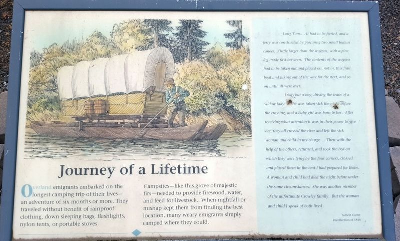
Overland emigrants embarked on the longest camping trip of their lives—and adventure of six months or more. They traveled without the benefit of rainproof clothing, down sleeping bags, flashlights, nylon tents, or portable stoves.
Campsites—like this grove of majestic firs—needed to provide firewood, water, and feed for livestock. When nightfall or mishap kept them from finding the best location, many weary emigrants simply camped where they could.
Long Tom....It had to be ferried, and a ferry was constructed by procuring two small Indian canoes, a little larger than the wagons, with a pine log made fast between. The contents of the wagons had to be taken out and placed on, not in, this frail boat and taking out of the way for the next, and so on until all were over.
I was but a boy, driving the team of a widow lady.... She was taken sick the night before the crossing, and a baby girl was born to her. After receiving what attention it was in their power to give her, they all had crossed the river and left the sick woman and child in my charge.... Then with the help of the others, returned, and took the bed on which they were lying by the four corners, crossed and placed them in the tent I had prepared for them. A woman and child had died the night before under the same circumstances. She was another member of the unfortunate Crowley family. But the woman and child I speak of both lived.
Tolbert Carter
Recollection of 1846
Erected by Applegate Trail Coalition.
Topics and series. This historical marker is listed in these topic lists: Roads & Vehicles • Settlements & Settlers. In addition, it is included in the Applegate Trail series list. A significant historical month for this entry is August 1846.
Location. 44° 18.933′ N, 123° 17.844′ W. Marker is in Monroe, Oregon, in Benton County. Marker is at the intersection of Pacific Hwy (U.S. 99) and Main Street, on the right when traveling south on Pacific Hwy. Touch for map. Marker is in this post office area: Monroe OR 97456, United States of America. Touch for directions.
Other nearby markers. At least 8 other markers are within 9 miles of this marker, measured as the crow flies. The Belknap Settlement (approx. 0.2 miles away); Wilhelm Mill Water Wheel (approx. ¼ mile away); Ebenezer Schoolhouse (approx. 3.2 miles away); a different marker also named Applegate Trail (approx. 4.3 miles away); “The Struggle Has Ended” (approx. 7.1 miles away); Lee House (approx. 8.1 miles away); Junction City — A Brief History (approx. 8.1 miles away); Locomotive 418 (approx. 8.2 miles away). Touch for a list and map of all markers in Monroe.
Credits. This page was last revised on April 26, 2018. It was originally submitted on April 26, 2018, by Douglass Halvorsen of Klamath Falls, Oregon. This page has been viewed 640 times since then and 114 times this year. Photos: 1, 2, 3. submitted on April 26, 2018, by Douglass Halvorsen of Klamath Falls, Oregon. • Andrew Ruppenstein was the editor who published this page.


