Cumberland Township near Gettysburg in Adams County, Pennsylvania — The American Northeast (Mid-Atlantic)
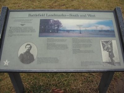
Battlefield Landmarks—South and West
July 3, 1863 - Third Day
"…the enemy is advancing. Every eye could see the legions, an overwhelming resistless tide of an ocean of armed men sweeping upon us!"
1st Lt. Frank A. Haskell, U.S.A.
Aide to Brig. Gen. John Gibbon
You are standing at the Union position on Cemetery Ridge, looking southwest toward the Confederate position on Seminary Ridge. It was across this ground that Pickett's Confederate infantry attacked on the afternoon of July 3.
The landscape today looks much as it did in 1863.
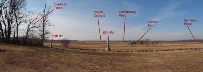
(Points highlighted from the panoramic view):
(1) Copse of Trees
confederate soldiers penetrated the Union line as far as this clump of trees. Just behind the trees along Hancock Avenue stands the High Water Mark Monument.
(2) Emmitsburg Road
This historic, sunken road bisects the fields over which the Confederates attacked on the afternoon of July 3. When Pickett's ranks reached the road, they performed a left oblique (turned left 45°) before charging the stone wall in front of you. Rail fences that bordered the road slowed their progress.
(3) Codori Farm
The two-story brick house and log barn of Nicholas Codori stood in the path of Pickett's attacking Confederates. The 5,000 Virginians passed on either side of the farm buildings as they marched in this direction.
A number of wounded Confederates took refuge in the house and barn. Pickett himself may have observed the progress of the attack from here. After the war the house was enlarged and a new barn was built.
(4) Seminary Ridge
General Lee positioned his Confederate First and Third Corps along the tree line of this gentle ridge on July 2. On the 3rd he launched "Pickett's Charge" from here.
Erected by Gettysburg National Military Park.
Topics. This historical marker is listed in this topic list: War, US Civil. A significant historical date for this entry is July 3, 1863.
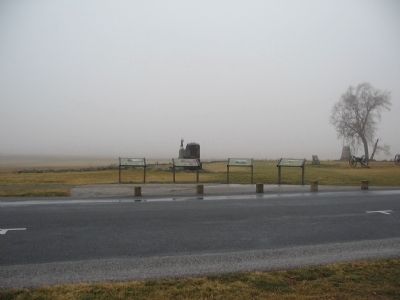
Location. This marker has been replaced by another marker nearby. It was located near 39° 48.769′ N, 77° 14.136′ W. Marker was near Gettysburg, Pennsylvania, in Adams County. It was in Cumberland Township. Marker was on Hancock Avenue, on the left when traveling north. Located near the "Copse of Trees" on Cemetery Ridge in Gettysburg National Military Park. Touch for map. Marker was in this post office area: Gettysburg PA 17325, United States of America. Touch for directions.
Other nearby markers. At least 8 other markers are within walking distance of this location. A Change in Plans (here, next to this marker); A Thunderous Duel (here, next to this marker); Against All Odds (here, next to this marker); Death at the Wall (a few steps from this marker); 72nd Regiment Pennsylvania Volunteers (a few steps from this marker); First Pennsylvania Cavalry (a few steps from this marker); Major General Alexander Webb (within shouting distance of this marker); 106th Pennsylvania Infantry (within shouting distance of this marker). Touch for a list and map of all markers in Gettysburg.
More about this marker. In the upper center is a photo of the panoramic view described in the text.
To the lower center is a portrait of Brig. Gen. Alexander S. Webb who commanded a Pennsylvania brigade positioned near the Copse of Trees. When fear paralyzed some of his soldiers, Webb gallantly took hold of the colors to lead them forward. Preferring death to defeat, he wrote his wife, "When my men fell back, I almost wished to get killed."
On the lower right is a photo of Pvt. Marshall Sherman of the 1st Minnesota Infantry earned the Medal of Honor for helping to repulse Pickett's Charge near the Copse of Trees. In that action he captured the Confederate battle flag in the photo.
Related marker. Click here for another marker that is related to this marker.
New Marker At This Location titled "A Change in Plans".
Credits. This page was last revised on February 7, 2023. It was originally submitted on February 14, 2009, by Craig Swain of Leesburg, Virginia. This page has been viewed 1,321 times since then and 14 times this year. Photos: 1, 2, 3. submitted on February 14, 2009, by Craig Swain of Leesburg, Virginia. 4. submitted on March 29, 2009, by Craig Swain of Leesburg, Virginia.


