Port Murray in Warren County, New Jersey — The American Northeast (Mid-Atlantic)
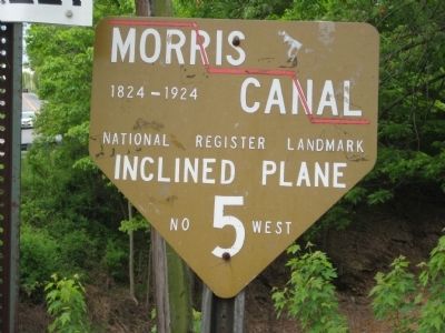
Morris Canal
1824 - 1924
Inclined Plane
No. 5 West
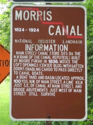
Nearby informational marker (see photo #2):
Main Street canal store sits on the N.W. bank of the canal. Reputedly built by Moore Furan in 1836. Notice the loft openings (center bldg.) with batten doors enabling cargo to pass directly to canal boats.
A boat yard and basin located approx. 100 yards N.W. of Main Street, a lime kiln just S.W. of canal at Main Street, and bridge abutements just west of Main Street still survive.
Topics and series. This historical marker is listed in this topic list: Waterways & Vessels. In addition, it is included in the Morris Canal series list. A significant historical year for this entry is 1836.
Location. 40° 47.14′ N, 74° 54.98′ W. Marker is in Port Murray, New Jersey, in Warren County. Marker is at the intersection of Main Street and Canal Lane, on the right when traveling south on Main Street. Touch for map. Marker is in this post office area: Port Murray NJ 07865, United States of America. Touch for directions.
Other nearby markers. At least 8 other markers are within 4 miles of this marker, measured as the crow flies. Mansfield Township Veterans Monument (about 500 feet away, measured in a direct line); Welcome To The Twp. Of Lebanon (approx. 0.9 miles away); Triple Arch Stone Bridge (approx. 1.2 miles away); Timberswamp Farm (approx. 1.6 miles away); Revolutionary Army Route (approx. 2.8 miles away); Pioneer Methodist Bishop Francis Asbury (approx. 2.9 miles away); Site of Mount Bethel Evangelical Lutheran Church and Cemetery (approx. 3.1 miles away); Swackhammer Church Cemetery (approx. 3.3 miles away).
Regarding Morris Canal. Port Murray was named for James B. Murray, the third president of the Morris Canal and Banking Company. Plane 5 West (a 64 foot elevation change) was just west of the village.
Also see . . .
1. Morris Canal Locks and Planes: World's Greatest Canal Hill Climber. Canal Society of New Jersey website entry:
Through a series of water turbine powered inclined planes, locks and aqueducts built above and across rivers, the Morris Canal was the world's biggest hill climber... (Submitted on May 22, 2009.)
2. The Morris Canal Greenway. Greenway website entry (Submitted on November 29, 2021, by Larry Gertner of New York, New York.)
Credits. This page was last revised on March 26, 2022. It was originally submitted on May 18, 2009, by Alan Edelson of Union Twsp., New Jersey. This page has been viewed 1,260 times since then and 32 times this year. Photos: 1, 2. submitted on May 18, 2009, by Alan Edelson of Union Twsp., New Jersey. • Kevin W. was the editor who published this page.
Editor’s want-list for this marker. Pictures of boat yard and basin, lime kiln, bridge abutements mentioned on the informational marker. • Can you help?

