Orwell in Addison County, Vermont — The American Northeast (New England)
Lake Champlain and the American Revolution
Mount Independence State Historic Site
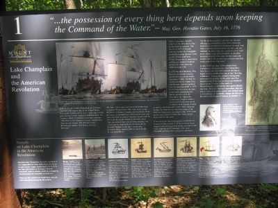
“ . . . the possession of every thing here depends upon keeping the Command of the Water.”
- Maj. Gen. Horatio Gates, July 16, 1776
In front of you is Lake Champlain, at 120 miles long the sixth largest lake in the United States. For nearly 10,000 years it was a major travel route and resource for the original inhabitants here. The Iroquois called it Caniaderi-Guarunte, meaning “The Door to the Country,” because it penetrated deep into the forests. The Abenaki name, Bitawbagok, means “The Waters that Lie Between.”
The lake, which runs north from Skenesborough (renamed Whitehall in 1786), New York, to the Province of Quebec, Canada, had enormous strategic value. It provided easy north-south travel and was contained by natural obstacles at each end. To the south the height of land at Fort Ann, New York, prevented large vessels from entering into or leaving the Hudson River. To the north the Chambly Rapids on the lake’s outlet, the Richelieu River, halted traffic to and from the St. Lawrence River.
Native Americans vied for control of the lake and its bordering hunting grounds. The travels in 1609 of French explorer Samuel de Champlain kindled European interest in the region. France and Great Britain fought for its possession and the vast natural resources during four wars, from the 1680s through 1763.
In 1775 the Revolutionary War between American colonists and the British arrived in the Champlain Valley. On May 10 Americans led by Ethan Allen and Benedict Arnold captured Fort Ticonderoga (built in 1755 by the French) across the lake, temporarily eliminating the British presence on Lake Champlain. In August the Continental Congress authorized an American army attack on British-held Canada, hoping to make it the fourteenth colony. That campaign failing, the demoralized American army of the Northern Department retreated in July 1776 south on the lake to Crown Point, New York, eleven miles north of this spot.
It was there the American generals resolved, at a Council of War on July 7, 1776, to “retire immediately to the strong ground on the east side of the Lake, opposite to Ticonderoga.” Col. John Trumbull of Connecticut praised its attributes:
“At the northern point, it ran low into the lake, offering a good landing place; from thence the land rose to an almost level plateau, elevated from fifty to seventy-five feet above the lake, and surrounded, on three sides, by a natural wall of rock, every where steep, and sometimes an absolute precipice sinking into the lake. On the fourth and eastern side of the position ran a morass and deep creek at the foot of the rock.”
In
July 1776 less than 3,000 soldiers from Connecticut, Massachusetts, New Hampshire, New Jersey, and New York crossed the lake to began carving fortifications out of this “howling wilderness,” making the naturally strong point even more formidable. At the same time Gen. Benedict Arnold directed an American shipbuilding program 25 miles to the south, at Skenesborough, to defend the lake against British warships. Between June and September, ship carpenters launched twelve vessels and outfitted them at Ticonderoga, to eventually engage the British to the north at the Battle of Valcour on October 11.
Vessels on Lake Champlain in the American Revolution
Because Lake Champlain was self-contained, it was impossible for large boats from elsewhere to gain access. Large vessels had to be built in the lake and remain in its waters. Smaller watercraft, such as canoes, could be portaged or carried around the waterfalls at each end.
These are the vessels you would have seen on Lake Champlain during the Revolution.
Bateau: Versatile, 20 to 30 foot long, over 6 feet wide, flat-bottomed craft capable of carrying large quantities of cargo and troops. Primarily powered by oars. Sometimes short masts were installed to hold a small sail.
Canoe: Birch bark canoes, first built by Native Americans in the Late Woodland period (1,000 to 500
years ago), were used by the Natives and Europeans alike to travel swiftly in these waters.
Gondola or Gunboat: The 54-foot American boats had flat bottoms, single masts with two sails, sweeps for rowing, three cannon, and crews of forty-five, and were unwieldy in contrary winds. British boats, about 38 feet long, had one sail and sweeps, smaller crews, and one cannon in the bow.
Radeau: Large, flat bottom vessels carrying a large number of heavy cannon. Sailed very poorly in most conditions. The British Thunderer was over 90-feet long and 33-feet wide.
Row Galley: Easy to sail, 72-foot long and nearly 20 feet wide, two-masted vessels carrying 8 to 12 cannons. If winds failed, the crews used large sweeps to row. Perfectly suited for the poorly trained American crews.
Schooner: Two-masted, square-rigged vessels from 45 to over 60 feet long and carrying from 8 to 16 cannon.
Ship: Three-masted vessels used by the British, about 90 to 100 feet long, which could carry 18 to 20 nine and twelve pound cannons, ranking them as very powerful in comparison to the American vessels.
Sloop: Lightly-armed vessels 85 to 95 feet long with a single mast and a fore and aft rig which permitted sailing in all winds.
Erected by Mount Independence State Historic Site.
Topics. This historical marker is listed in these topic lists: War, US Revolutionary • Waterways & Vessels. A significant historical month for this entry is May 1864.
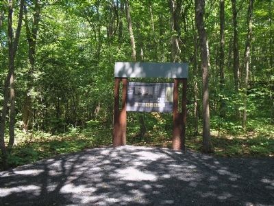
Location. 43° 49.35′ N, 73° 22.899′ W. Marker is in Orwell, Vermont, in Addison County. Marker can be reached from Mount Independence Road, on the right when traveling south. Marker is along the walking trail in Mount Independence State Historic Site. Touch for map. Marker is in this post office area: Orwell VT 05760, United States of America. Touch for directions.
Other nearby markers. At least 8 other markers are within walking distance of this marker. German Hut – 1777 (about 300 feet away, measured in a direct line); The American Southern Defenses – 1776-1777 (about 400 feet away); British Blockhouse - 1777 (about 500 feet away); Southern Battery – 1777 (about 600 feet away); Foundation -1776 or 1777 (about 700 feet away); Storehouse - 1776 (about 700 feet away); Third Brigade Encampment – 1776 (about 800 feet away); General Hospital – 1777 (approx. 0.2 miles away). Touch for a list and map of all markers in Orwell.
More about this marker. The top of the marker contains a painting by Greg Harlin of British ships in the lake. It has the caption, “In June 1777 Lt. Gen. John Burgoyne’s British fleet bore down on Lake Champlain toward Mount Independence and Fort Ticonderoga.” and is from the collection of the Mount Independence State Historic Site. The right side of the marker features a Revolutionary-era map of the Mount Independence area. Next to this is a picture of Benedict Arnold with the caption, “In the summer of 1776 Benedict Arnold proposed and oversaw the construction of an American fleet to defend Lake Champlain against the British.” The bottom of the marker contains pictures of the vessels mentioned on the marker.
Related markers. Click here for a list of markers that are related to this marker. This series of markers are found on the walking trails in Mount Independence State Historic Site.
Credits. This page was last revised on November 3, 2020. It was originally submitted on May 28, 2009, by Bill Coughlin of Woodland Park, New Jersey. This page has been viewed 2,515 times since then and 49 times this year. Photos: 1, 2, 3. submitted on May 28, 2009, by Bill Coughlin of Woodland Park, New Jersey.


