Near Middleton in Canyon County, Idaho — The American West (Mountains)
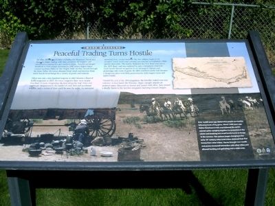
Peaceful Trading Turns Hostile
Ward Massacre
What was only a few hundred wagons in 1842 became a flood of 8,000 emigrants in 1853. For every emigrant there were nearly four head of stock overgrazing the land along the trail. Trees and sagebrush disappeared in the smoke of cook fires and accidental wildfire, and a curtain of dust could be seen for miles. As resources stretched thin, contact between the two cultures began to be strained. Insult, injury and criminal acts resulted in retaliation, often against innocents. The nearby Hudson's Bay Fort Boise was lost in the 1853 flood, and was replaced by only a temporary structure. Local bands blamed emigrants for an increase in disease and poisonings and a loss of game. By 1854, southern Idaho had became a dangerous place with little protection for both wagon trains and native bands.
Toward the end of the 1854 migration, the hostility boiled over into violence. A local band, the Winnasc, began outright attacks on isolated trains. Mounted on horses and armed with rifles, they proved a deadly threat to the last few emigrants hurrying toward Oregon.
Over 12,000 years ago, Idaho's first people survived by following herds of big game. About 7,000 years ago, Native Americans in this area followed the earth's natural cycles - camping together for protection in the winter and breaking into small family bands to forage in the summer. This pattern began changing in the early 18th century, when local tribes obtained their first horses from other tribes. Horses brought new wealth and power, increased interaction with other tribes and allowed hunting and gathering over a wider area.
Topics. This historical marker is listed in these topic lists: Native Americans • Settlements & Settlers. A significant historical year for this entry is 1842.
Location. 43° 40.631′ N, 116° 36.536′ W. Marker is near Middleton, Idaho, in Canyon County. Marker is on Lincoln Road, 0.2 miles east of Middleton Road, on the left when traveling east. Touch for map. Marker is in this post office area: Caldwell ID 83605, United States of America. Touch for directions.
Other nearby markers. At least 8 other markers are within 4 miles of this marker, measured as the crow flies. Hostility Erupts Into Violence (here, next to this marker); To the Memory of the Pioneers (here, next to this marker); Violence is Avenged (here, next to this marker); The Ward Massacre
(within shouting distance of this marker); Idaho's First Heroine - Madame Marie Dorion (approx. 3.8 miles away); A.K. Steunenberg, Frank Steunenberg (approx. 4 miles away); Caldwell Train Depot (approx. 4 miles away); Emigrant Crossing (approx. 4 miles away). Touch for a list and map of all markers in Middleton.
Additional keywords. Oregon Trail, Fort Boise
Credits. This page was last revised on June 16, 2016. It was originally submitted on September 9, 2009, by Rebecca Maxwell of Boise, Idaho. This page has been viewed 2,154 times since then and 52 times this year. Photos: 1, 2. submitted on September 9, 2009, by Rebecca Maxwell of Boise, Idaho. • Craig Swain was the editor who published this page.

