Near Sudley in Prince William County, Virginia — The American South (Mid-Atlantic)
Jackson’s Route
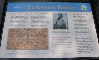
In 1861, small farms surrounded Bull Run. Small roads were the main transportation routes to the Warrenton Turnpike (Route 29), Sudley Road (Route 234) and the Manassas Gap Railroad. The entrance road here follows a section of a 19th-century farm lane that connected the Weir family’s Liberia Plantation and the Lewis family’s Portici Plantation. It was on this road that General Thomas J. Jackson led his First Virginia Brigade to the Battle of First Manassas (Bull Run) on July 21, 1861. The brigade included the 2nd, 4th, 5th, 27th, and 33rd Virginia regiments. The majority of Confederate soldiers who fought that day marched northward into battle from Blackburn Ford and Manassas Junction vicinities.
“Our Brigade was ordered to double-quick for about five miles…running that distance like panting dogs with flopping tongues, with our mouths and throats full of the impalpable red dust of that red clay country, thursting for water almost unto death, and worn and weary indescribably.” Quotation: C.A. Fonerden described the rush to Henry Hill. He was a Corporal in the 27th Virginia Infantry, Jackson’s Brigade, during the battle. From C.A. Fonerden, A Brief History of the Military Career of Carpenter’s Battery, 1911.
(Sidebar):
Rushing to Battle
Jackson's brigade arrived at Manassas Junction by train on the morning of July 20. Commanding Confederate General P.G.T. Beauregard deployed them between Blackburn's and Mitchell’s Fords. On July 21 at 9 a.m., Beauregard sent Jackson’s brigade north to respond to a report of increased gunfire. Jackson hurried his men to meet the Federal soldiers in the vicinity of Henry Hill.
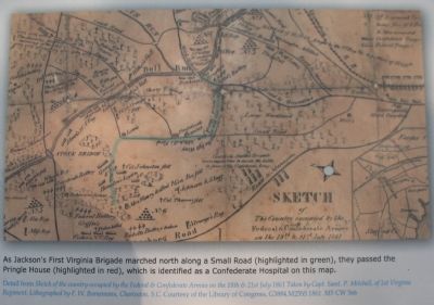
About one mile before reaching Henry Hill, Jackson’s soldiers passed the Pringle House (Ben Lomond). First Virginia Brigade surgeon Dr. Hunter McGuire designated the house as a hospital for casualties of the intensifying battle. Wounded soldiers were conveyed from the battlefield to the makeshift hospital along this road.
Topics. This historical marker is listed in this topic list: War, US Civil. A significant historical month for this entry is July 1921.
Location. 38° 47.332′ N, 77° 30.328′ W. Marker is near Sudley, Virginia, in Prince William County. Marker is at the intersection of Sudley Manor Drive and Copeland Drive, on the right when traveling east on Sudley Manor Drive. Located on the drive into the parking area behind the Ben Lomond Manor. Touch for map. Marker is in this post office area: Manassas VA 20109, United States of America. Touch for directions.
Other nearby markers. At least 8 other markers are within 2 miles of this marker, measured as the crow flies. Ben Lomond (within shouting distance of this marker); Kitchen Yard (within shouting distance of this marker); Ben Lomond Farm (within shouting distance of this marker); A Historic Place / Ben Lomond Old Rose Garden (within shouting distance of this marker); The Ben Lomond Manor House (within shouting distance of this marker); Slave Quarter (about 400 feet away, measured in a direct line); Headwaters to Baywaters (approx. 0.9 miles away); Civil War Winter Quarters (approx. 1.2 miles away). Touch for a list and map of all markers in Sudley.
More about this marker. A map showing the 1st Virginia’s march is captioned, “As Jackson’s First Virginia Brigade marched north along a Small Road (highlighted in green), they passed the Pringle House (highlighted in red), which is identified as a Confederate Hospital on this map.”
A portrait of General Jackson is captioned, "General Thomas J. Jackson (1824–1863) commanded the First Virginia Brigade at the Battle of First Manassas (Bull Run). During the battle, Brigadier General Barnard Bee gave Jackson the moniker “Stonewall.”
Also see . . . The Stonewall Brigade. After Gen. Bee's nickname for Gen. Jackson became common, the Brigade also was granted the same nickname - "The Stonewall Brigade." Serving through the war, and participating in all major campaigns, it fought in four different states and the District of Columbia. (Submitted on September 12, 2007, by Craig Swain of Leesburg, Virginia.)
Additional keywords. First Manassas Campaign
Credits. This page was last revised on November 29, 2021. It was originally submitted on September 12, 2007, by Craig Swain of Leesburg, Virginia. This page has been viewed 1,849 times since then and 45 times this year. Photos: 1, 2. submitted on September 12, 2007, by Craig Swain of Leesburg, Virginia. 3. submitted on April 6, 2010. • J. J. Prats was the editor who published this page.


