Bethlehem Village in Litchfield County, Connecticut — The American Northeast (New England)
Bethlehem
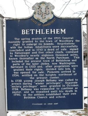
The spring session of the 1703 General Assembly granted to the town of Woodbury the right to enlarge its bounds. Negotiations with the Indian inhabitants were successfully concluded and in 1710 a deed of sale, signed by Nunawague and five other chiefs, conveyed to Woodbury nearly eighteen thousand acres, known thereafter as the North Purchase. This included the present town of Bethlehem and parts of the later Judea, now Washington. Surveyed in 1723 and, after proprietors were granted their rights, divided into lots, it was opened for sale. Pioneers arrived in 1734, settling on the heights northeast of the present center.
In 1738 young Joseph Bellamy was called to preach during “winter privileges”. Separate “society privileges” were granted in October, 1739. Bellamy was requested to continue as pastor, and so remained until his death in 1790, as the settlers established their own Bethlem Church and school.
Marker Reverse:
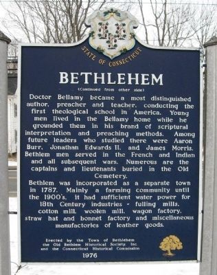
Doctor Bellamy became a most distinguished author, preacher and teacher, conducting the first theological school in America. Young men lived in the Bellamy home while he grounded them in his brand of scriptural interpretation and preaching methods. Among future leaders who studied there were Aaron Burr, Jonathan Edwards II, and James Morris. Bethlem men served in the French and Indian and all subsequent wars. Numerous are the captains and lieutenants buried in the Old Cemetery.
Bethlem was incorporated as a separate town in 1787. Mainly a farming community until the 1900s, it had sufficient water power for 18th Century industries – fulling mills, cotton mill, woolen mill, wagon factory, straw hat and bonnet factory and miscellaneous manufactories of leather goods.
Erected 1976 by Town of Bethlehem, The Old Historical Bethlehem Society, Inc., Connecticut Historical Commission.
Topics. This historical marker is listed in these topic lists: Colonial Era • Settlements & Settlers. A significant historical month for this entry is October 1739.
Location. 41° 38.223′ N, 73° 12.533′ W. Marker is in Bethlehem, Connecticut, in Litchfield County. It is in Bethlehem Village. Marker is on Main Street South (Connecticut Route 61) 0.1 miles north of Sunny Ridge Road, on the left when traveling north. Located in front of Bethlehem Town Hall. Touch for map. Marker is at or near this postal address: 36 Main Street South, Bethlehem CT 06751, United States of America. Touch for directions.
Other nearby markers. At least 8 other markers are within walking distance of this marker. Bethlehem Civil War and World War I Memorial (about 600 feet away, measured in a direct line); Bethlehem Revolutionary War Memorial (about 700 feet away); Bethlehem War of 1812 Memorial (about 700 feet away); Bethlehem Korean War Memorial (about 700 feet away); Bethlehem Vietnam War Memorial (about 700 feet away); Bethlehem World War II Memorial (about 700 feet away); Dr. Bellamy Meetinghouse (approx. 0.2 miles away); Bellamy - Ferriday House (approx. 0.2 miles away). Touch for a list and map of all markers in Bethlehem.
Credits. This page was last revised on February 10, 2023. It was originally submitted on January 15, 2010, by Michael Herrick of Southbury, Connecticut. This page has been viewed 1,117 times since then and 19 times this year. Photos: 1, 2, 3, 4. submitted on January 15, 2010, by Michael Herrick of Southbury, Connecticut. • Kevin W. was the editor who published this page.


