Columbia in Maury County, Tennessee — The American South (East South Central)
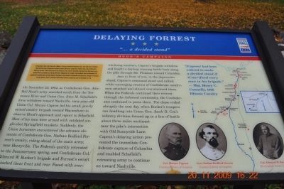
Delaying Forrest
"...a decided stand"
— Hood's Campaign —
Inscription.
(Preface):
In September 1864, after Union Gen. William T. Sherman defeated Confederate Gen. John Bell Hood at Atlanta, Hood led the Army of Tennessee northwest against Sherman's supply lines. Rather than contest Sherman's "March to the Sea," Hood moved north into Tennessee. Gen. John M. Schofield, detached from Sherman's army, delayed Hood at Columbia and Spring Hill before falling back to Franklin. The bloodbath there on November 30 crippled the Confederates, but they followed Schofield to the outskirts of Nashville and Union Gen. George H. Thomas's strong defenses. Hood's campaign ended when Thomas crushed his army on December 15-16.
(Main Body of Text):
On November 23, 1864 as Confederate Gen. John Bell Hood's army marched north from the Tennessee River and Union Gen. John M. Schofield's forces withdrew toward Nashville, sixty-year-old Union Col. Horace Capron led his small, poorly armed cavalry brigade toward Waynesboro to observe Hood's approach and report to Schofield. Most of his men were armed with outdated single-shot Springfield muskets. Suddenly, the Union horsemen encountered the advance elements of Confederate Gen. Nathan Bedford Forrest's cavalry, riding ahead of the main army, near Henryville. The Federals quickly retreated to Summertown spring, and Confederate Col. Edmund W. Rucker's brigade and Forrest's escort attacked them front and rear. Faced with overwhelming numbers, Capron's brigade withdrew and fought a daylong running battle back along the pike through Mt. Pleasant toward Columbia.
Just in front of you, the depression ahead, Capron's command stood and rallied while converging swarms of Confederate cavalrymen attacked and almost overwhelmed them. When the Federals continued their retreat through the Ashwood community, the Confederates continued to press them. The chase ended abruptly the next day, when Rucker's troopers ran headlong into Union Gen. Jacob D. Cox's infantry division formed up in a line of battle about three miles northeast near the pike's intersection with Old Sunnyside Lane. Capron's delaying action prevented the immediate Confederate capture of Columbia and enabled Schofield's retreating army to continue on toward Nashville.
"[Capron] had been ordered to make a decided stand if it sacrificed every man in his brigade." -Maj. Henry C. Connelly, 14th Illinois Cavalry
Erected by Tennessee Civil War Trails.
Topics and series. This historical marker is listed in this topic list: War, US Civil. In addition, it is included in the Tennessee Civil War Trails series list. A significant historical month for this entry is September 1864.
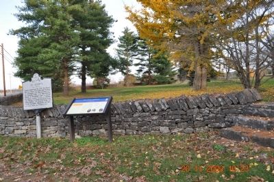
Location. 35° 34.467′ N, 87° 8.381′ W. Marker is in Columbia, Tennessee, in Maury County. Marker is on Trotwood Avenue (State Highway 243), on the right when traveling east. Located at the entrance to the St. Johns Church and Cemetery. Touch for map. Marker is in this post office area: Columbia TN 38401, United States of America. Touch for directions.
Other nearby markers. At least 8 other markers are within 4 miles of this marker, measured as the crow flies. St. John's (here, next to this marker); St. John's Episcopal Church (within shouting distance of this marker); Forrest and Capron (about 500 feet away, measured in a direct line); Rattle and Snap Plantation (approx. 1.1 miles away); Sam Watkins (approx. 1.7 miles away); Hood's Maneuver (approx. 2.3 miles away); Zion (approx. 2.7 miles away); Road to Nashville (approx. 3.9 miles away). Touch for a list and map of all markers in Columbia.
Also see . . .
1. Horace Capron. Horace Capron (August 31, 1804 – February 22, 1885) was an American businessman and agriculturalist. (Submitted on March 16, 2010, by Sandra Hughes Tidwell of Killen, Alabama, USA.)
2. John Bell Hood. John Bell Hood (June 1 or June 29, 1831 – August 30, 1879) was a Confederate general during the American Civil War. (Submitted on March 16, 2010, by Sandra Hughes Tidwell of Killen, Alabama, USA.)
3. John Schofield. John McAllister Schofield (September 29, 1831 – March 4, 1906) was an American soldier who held major commands during the American Civil War. He later served as U.S. Secretary of War and commanding general of the United States Army. (Submitted on March 16, 2010, by Sandra Hughes Tidwell of Killen, Alabama, USA.)
4. Nathan Bedford Forrest. Nathan Bedford Forrest (July 13, 1821 – October 29, 1877) was a lieutenant general in the Confederate Army during the American Civil War. (Submitted on March 16, 2010, by Sandra Hughes Tidwell of Killen, Alabama, USA.)
5. Edmund Rucker. Edmund Winchester Rucker (1835 – 1924) was a Confederate officer during the American Civil War. He was given the title of "General" as an honorary award after the war, when he became an industrial leader of Birmingham, Alabama. Fort Rucker was named in honor of him. He is buried in Birmingham's Oak Hill Cemetery. (Submitted on March 16, 2010, by Sandra Hughes Tidwell of Killen, Alabama, USA.)
Credits. This page was last revised on June 16, 2016. It was originally submitted on March 16, 2010, by Sandra Hughes Tidwell of Killen, Alabama, USA. This page has been viewed 1,683 times since then and 32 times this year. Photos: 1, 2. submitted on March 16, 2010, by Sandra Hughes Tidwell of Killen, Alabama, USA. • Craig Swain was the editor who published this page.

