Wurtsboro in Sullivan County, New York — The American Northeast (Mid-Atlantic)
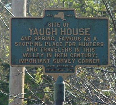
Site of Yaugh House
Erected 1936 by State Education Department.
Topics. This historical marker is listed in these topic lists: Colonial Era • Political Subdivisions.
Location. 41° 34.79′ N, 74° 29.042′ W. Marker is in Wurtsboro, New York, in Sullivan County. Marker is on Kingston Avenue (U.S. 209) 0.3 miles Sullivan Street (County Road 172), on the right when traveling north. Touch for map. Marker is at or near this postal address: 264 US 209, Wurtsboro NY 12790, United States of America. Touch for directions.
Other nearby markers. At least 8 other markers are within 2 miles of this marker, measured as the crow flies. Nathaniel Sackett (about 600 feet away, measured in a direct line); Wurtsboro Veterans Monument (approx. 0.3 miles away); Canal Office (approx. 0.4 miles away); Canal Bridge (approx. 0.4 miles away); Wurtsboro (approx. 0.4 miles away); a different marker also named Wurtsboro (approx. 0.4 miles away); Original Snubbing (approx. 0.4 miles away); Fort Devens (approx. 1.6 miles away). Touch for a list and map of all markers in Wurtsboro.
Additional commentary.
1. Documents of the Assembly of the State of New York, Seventy Fifth Session, No. 59
In Assembly, Feb. 14, 1852.
Of the committee on claims on the petition of David Hulse and Jonathan O. Dunning for relief.
Mr. Gilbert, from the committee on claims, to which were referred the petitions and papers of David Hulse and Jonathan O. Dunning, asking payment for services rendered by them under appointment of the Surveyor-General of this State,
REPORTS:
That on the 20th day of December, 1847, the Surveyor-General appointed the said petitioners as his deputies to perform certain services, which appointment was in the words and figures following, viz:
(Copy Appointment.)
STATE OF NEW YORK,
Surveyor-general's Office,
Albany, Dec. 20th, 1847.
To David Hulse, Esq., of Cuddebackville, Orange co., and Jonathan O. Dunning, Esq., of Bloomingburgh, Sullivan co.:
Gentlemen:—The supervisors of the several towns of Lumberland, Forestburgh, Bethel, Mamakating, Thompson and Cochecton, in the county of Sullivan, by letter over date of 17th of December, instant, have represented to me that great uncertainty exists in reference to the boundary line between the said towns, by reason that the division line between the Minisink and Hardenburgh patents has never been actually surveyed and located, as they are informed, and requesting me to cause the division line between said patents to be surveyed and established from the Yaugh house, or hunting house, (as named in the survey of Charles Webb, surveyor, appointed to survey and locate the Minisink patent,) to the point established by said Webb on the Delaware river, as the northwest corner of Minisink patent, and the south-west corner of the Hardenburgh patent.
As the several towns above named are bounded by the line between said patents, it becomes important that the true line should be established. And you, the said David Hulse and Jonathan O. Dunning, having been recommended to me by the said supervisors, as competent and skilful surveyors, I do, therefore, hereby appoint you my deputies and request you at your earliest convenience to associate together, and according to the best of your ability and skill, ascertain and correctly run the line between the Minisink and Hardenburgh patents, from the Yaugh house to the Delaware river, and to erect suitable monuments in said line, and at the corners thereof, and make your return to this office on oath, accompanied by a map and field notes of said line, that a distinct description may be given in any decision that may be had thereon.
You will give notice to the supervisors of said towns to attend you in making said survey, whose approval or dissent of the location of said line by you, I request, may be endorsed on, or in some other way accompany your report.
I am unable to furnish you with any particular instructions to guide you in the proposed survey. It seems to be conceded that the Yaugh house, or hunting house, (so called) in the town of Mamakating, may be safely taken as the starting point, and then running westerly until the line strikes the Delaware river. The Minisink patent describes this line as running west by north from the Yaugh house to the Delaware river, and bears date Aug. 28th, 1704, being four years earlier than the Hardenburgh patent. The last mentioned patent describes the line as beginning at the north-east corner of the land granted to Ebenezer Wilson, Derrick Vandenburgh, &c, at Minisink, so running along their line north-westerly as said line runs to Fishkill river.
I find on a map in the Secretary's office, made by Charles Webb, in the year 1765, the north line of the Minisink patent as running from, the Yaugh house north 77° 45', west 2,360 chains.
The line from the Yaugh house to the Delaware river is laid down on all the maps as a straight line.
Please inform me on the receipt of this, if you accept the appointment and can enter upon the work without delay.
Very respectfully,
Yours, &c,
"H. HALSEY,'
Surveyor-General.
Source: Documents of the Assembly of the State of New York, Seventy Fifth Session, 1852, Volume 2, No. 28 to 88 inclusive. (Google Books http://tinyurl.com/2dcu9lp)
— Submitted May 17, 2010, by Clifton Patrick of Chester, NY, United States.
Credits. This page was last revised on October 3, 2016. It was originally submitted on May 9, 2010, by Clifton Patrick of Chester, NY, United States. This page has been viewed 1,459 times since then and 32 times this year. Photo 1. submitted on May 9, 2010, by Clifton Patrick of Chester, NY, United States. • Kevin W. was the editor who published this page.
Editor’s want-list for this marker. A wide shot of the marker and its surroundings. • Can you help?
