James Island in Secessionville in Charleston County, South Carolina — The American South (South Atlantic)
Battery Number 5
Inscription.
This was one of several Confederate earthworks constructed on the southwest portion of James Island in the summer of 1863. It was a significant part of the “New Line” or “Siege Line” intended to defend Charleston from Federal attacks up the Stono or Folly Rivers. This line replaced the 1861-62 lines that ran across James Island from Clark Sound to Wappoo Creek.
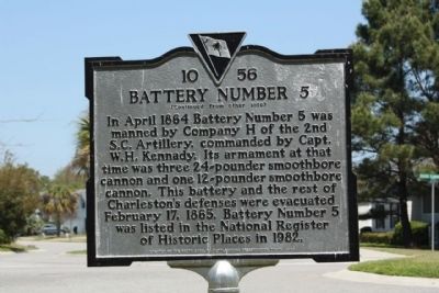
In April 1864 Battery Number 5 was manned by Company H of the 2nd S.C. Artillery, commanded by Capt. W.H. Kennady. Its armament at that time was three 24-pounder smoothbore cannon and one 12-pounder smoothbore cannon. This battery and the rest of Charleston’s defenses were evacuated February 17, 1865. Battery Number 5 was listed in the National Register of Historic Places in 1982.
Erected 2008 by The South Carolina Battleground Preservation Trust. (Marker Number 10-56.)
Topics. This historical marker is listed in this topic list: War, US Civil. A significant historical date for this entry is February 17, 1855.
Location. 32° 42.473′ N, 79° 57.208′ W. Marker is in Secessionville, South Carolina, in Charleston County. It is on James Island. Marker is on Seaside Plantation Drive near Opposite Planters Trace Drive, on the right when traveling east. Touch for map. Marker is in this post office area: Charleston SC 29412, United States of America. Touch for directions.
Other nearby markers. At least 8 other markers are within 2 miles of this marker, measured as the crow flies. Secessionville (approx. half a mile away); Battle of Secessionville (approx. half a mile away); Battery Reed (approx. ¾ mile away); Riversville / Battle of Secessionville (approx. 0.9 miles away); Hunter's Volunteers (approx. one mile away); Redoubt Number 3 (approx. 1.6 miles away); Mosquito Beach (approx. 1.6 miles away); Battle of Sol-Legare Island (approx. 2 miles away). Touch for a list and map of all markers in Secessionville.
Regarding Battery Number 5. Like its sister batteries, LeRoy and Battery Number 1, Battery Number 5 was part of Beauregard’s James Island Siege Line built in 1863 to replace General J.C. Pemberton’s faulty defense line. As part of this important siege line, Battery Number 5 was designed to protect against an infantry attack via the Secessionville region of southern James Island. Battery Number 5 also supplemented the firepower of the Secessionville batteries and was kept in good order, mounting four guns in 1865. Battery Number 5 is the eastern terminus of the James Island Siege Line. It overlooks Seaside Creek and Secessionville on the southern edge of James Island. The battery is an earth redan with its right and left faces measuring about 200 feet and the center face about 100 feet. The parapet is approximately 10 feet high. The powder magazine has been destroyed. Listed in the National Register August 11, 1982. (Historic Resources of Civil War Defenses of Charleston, 1861-1865)
Credits. This page was last revised on October 30, 2023. It was originally submitted on May 10, 2010, by Mike Stroud of Bluffton, South Carolina. This page has been viewed 26,003 times since then and 9,937 times this year. Photos: 1, 2. submitted on May 10, 2010, by Mike Stroud of Bluffton, South Carolina. 3, 4. submitted on August 6, 2013, by Bill Coughlin of Woodland Park, New Jersey. 5, 6, 7, 8, 9. submitted on May 10, 2010, by Mike Stroud of Bluffton, South Carolina. 10, 11. submitted on August 11, 2015, by Brandon Fletcher of Chattanooga, Tennessee.


