Near Atlantic Beach in Carteret County, North Carolina — The American South (South Atlantic)
Fort Macon
Guardian of Beaufort Harbor
— Burnside Expedition —
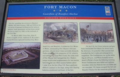
In March 1862, Union Gen. John G. Parke's brigade of Gen. Ambrose E. Burnside's Coastal Division captured Carolina City, Morehead City, and Beaufort. Confederate Col. Moses J. White, commanding Fort Macon's 403-man garrison, refused three Union surrender demands. Park established 22 companies of U.S. infantry and artillery at Hoop Pole Creek, five miles west of Fort Macon, and besieged the fort. Parke's troops constructed emplacements for two mortar batteries and one rifled cannon battery about ¾ mile from the fort. Four U.S. Navy gunboats offshore assisted in the siege, along with floating batteries positioned northeast of the fort.
On April 25, the Union batteries and gunboats bombarded Fort Macon for eleven hours. By afternoon, the powerful rifled cannons had breached the fort's walls and endangered its magazines. The Confederates ran up the white flag at 4:30 p.m., and White formally surrendered to Parke's forces the following morning. Seven Confederates were killed and eighteen wounded, while the Federals lost one killed and two wounded. U.S. forces occupied the fort and Beaufort Hotel for the remainder of the war.
Erected by North Carolina Civil War Trails.
Topics. This historical marker is listed in these topic lists: Forts and Castles • War, US Civil. A significant historical month for this entry is March 1862.
Location. 34° 41.849′ N, 76° 40.687′ W. Marker is near Atlantic Beach, North Carolina, in Carteret County. Marker is on Fort Macon Road, on the right when traveling east. Located in the parking lot at Fort Macon State Park. Touch for map. Marker is in this post office area: Atlantic Beach NC 28512, United States of America. Touch for directions.
Other nearby markers. At least 8 other markers are within walking distance of this marker. A different marker also named Fort Macon (within shouting distance of this marker); Queens Anne's Revenge (within shouting distance of this marker); Fort Macon Coast Guard Station (within shouting distance of this marker); World War II Defenses (within shouting distance of this marker); Fort Macon in the 1920s and 1930s (within shouting distance of this marker); The Military Post of Fort Macon in the Nineteenth Century (within shouting distance of this marker); Officers Quarters at Fort Macon (within shouting distance of this marker); World War II Barracks Area (within shouting distance of this marker). Touch for a list and map of all markers in Atlantic Beach.
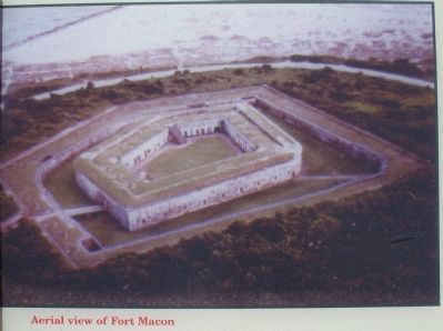
More about this marker. On the lower left is an Aerial view of Fort Macon. In the upper center is an illustration depicting a U.S. rifled cannon battery firing on Fort Macon. On the upper right is a depiction of the Surrender of Fort Macon.
Also see . . . Fort Macon State Park. A history of the fort. (Submitted on June 1, 2010, by Craig Swain of Leesburg, Virginia.)
Credits. This page was last revised on June 12, 2023. It was originally submitted on June 1, 2010, by Craig Swain of Leesburg, Virginia. This page has been viewed 1,089 times since then and 27 times this year. Photos: 1, 2, 3, 4. submitted on June 1, 2010, by Craig Swain of Leesburg, Virginia.


