Sullivans Island in Charleston County, South Carolina — The American South (South Atlantic)
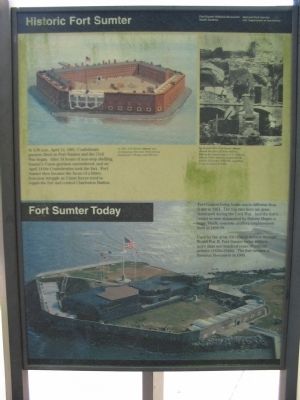
Historic Fort Sumter - Fort Sumter Today
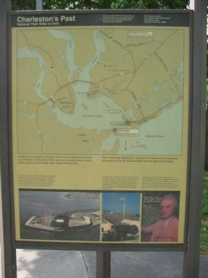
Charleston's Historic Past
At 4:30 a.m., April 12, 1861, Confederate gunners fired on Fort Sumter and the Civil War began. After 34 hours of non-stop shelling, Sumter's Union garrison surrendered, and on April 14 the Confederates took the fort. Fort Sumter then became the focus of a bitter, four-year struggle as Union forces tried to regain the fort and control Charleston Harbor.
Fort Sumter Today
Fort Sumter today looks much different than it did in 1861. The top two tiers are gone, destroyed during the Civil War. And the fort's center is now dominated by Battery Huger, a huge, black concrete artillery emplacement built in 1898-99.
Used by the army for coastal defense through World War II, Fort Sumter today reflects more than one hundred years of military activity (1930s-1940s). The fort became a National Monument in 1948.
Charleston's Historic Past
National Park Sites to Visit
Charleston has played a rich and varied role in America's history, as a defender of America's birth, home to founding fathers, trade center, ignitor of civil strife, and coastal defense link.
Three sites that display key elements of Charleston's storied past are preserved by the National Park Service and can be visited.
Fort Sumter, famous for the Civil War's opening battle, guards the entrance to Charleston Harbor. Reached only by boast, it was the focus of explosive conflict from 1861-65. Reduced to ruin by war's end, Fort Sumter was partially rebuilt and modernized, continuing as a military site until the end of World War II.
Fort Moultrie, on Sullivans Island at the mouth of Charleston Harbor, was the site of a Revolutionary War battle in which patriot troops repulsed the invading British Navy. Guarding Charleston for nearly 200 years, Fort Moultrie traces American coastal defenses from the nation's birth through World War II.
Charles Pinckney - patriot, statesman, and a framer of the Constitution - helped mold America in nearby Mt. Pleasant, part of Pinckney's coastal plantation, called Snee Farm, is preserved as Charles Pinckney National Historic Site. Features there provide a glimpse of America's early years.
Erected by Fort Sumter National Monument, South Carolina - National Park Service - U.S. Department of the Interior.
Topics. This historical marker is listed in these topic lists: Forts and Castles • War, US Civil. A significant historical month for this entry is April 1849.
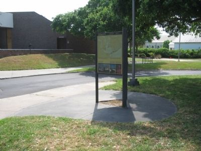
Location. 32° 45.639′ N, 79° 51.438′ W. Marker is on Sullivans Island, South Carolina, in Charleston County. Marker is on Middle Street, on the right when traveling west. Located in the parking lot behind the visitor center for Fort Moultrie. Touch for map. Marker is in this post office area: Sullivans Island SC 29482, United States of America. Touch for directions.
Other nearby markers. At least 8 other markers are within walking distance of this marker. Grave of General William Moultrie (a few steps from this marker); Defending Charleston (within shouting distance of this marker); Fort Moultrie Torpedo Storehouse (within shouting distance of this marker); Station Hospital (within shouting distance of this marker); a different marker also named Fort Moultrie Torpedo Storehouse (about 300 feet away, measured in a direct line); From Military Base to National Park (about 300 feet away); Oceola / Patapsco Dead (about 300 feet away); Northwest Bastionet (about 400 feet away). Touch for a list and map of all markers in Sullivans Island.
More about this marker. In the upper portion of the Fort Sumter marker is an illustration depicting Fort Sumter as built with the caption, In 1861, Fort Sumter was an imposing, three-tier, brick fortress designed for 135 guns and 650 men. On the upper right is a wartime photo showing damage to the fort. By August 1863, Fort Sumter showed the effect of Union shelling. During the longest siege in U.S. military history, Union batteries bombarded the fort for 22 months (1863-65), pounding it into a mound of rubble. The lower part of the marker displays an aerial photo of the fort today.
On the Charleston's Past side, a map shows the location of the three National Parks sites. At the lower part of that side are photos of Forts Sumter and Moultrie, along with a portrait of Pinckney.
Regarding Historic Fort Sumter - Fort Sumter Today. Although many maps show such, there is no ferry from Fort Moultrie to Fort Sumter. The closest access to Fort Sumter is at Patriot's Point (see link).
Also see . . .
1. Fort Sumter. National Park Service site. The site offers details regarding access to Fort Sumter. (Submitted on June 15, 2010, by Craig Swain of Leesburg, Virginia.)
2. Fort Moultrie. National Park Service site. (Submitted on June 15, 2010, by Craig Swain of Leesburg, Virginia.)
3. Charlest Pinckney National Historic Site. National Park Service site. (Submitted on June 15, 2010, by Craig Swain of Leesburg, Virginia.)
Credits. This page was last revised on June 16, 2016. It was originally submitted on June 15, 2010, by Craig Swain of Leesburg, Virginia. This page has been viewed 1,184 times since then and 49 times this year. Photos: 1, 2, 3. submitted on June 15, 2010, by Craig Swain of Leesburg, Virginia.


